JOHN S. ALLEN'S BICYCLE FACILITIES, LAWS AND PROGRAMS PAGES |
||
 |
Top: Home Page Up: Minneapolis Previous: Bicycle Plan |
 |
JOHN S. ALLEN'S BICYCLE FACILITIES, LAWS AND PROGRAMS PAGES |
||
 |
Top: Home Page Up: Minneapolis Previous: Bicycle Plan |
 |
Alec Kloss's comments[Minneapolis cyclist Alec Kloss, alec *at* SetFilePointer.com, e-mailed these thoughtful comments after reading my pages about Minneapolis-St. Paul bicycle facilities -- John S. Allen] I've been very much enjoying reading your articles on www.bikexprt.com. As a relatively recent (but very active year-round) bicycle commuter in Minneapolis, I'd like to add a few observations about your review of the bicycling facilities here. I think it's often missed that the Twin Cites are very sparsely populated. Here is some data from the 1997-1998 Census factbook:
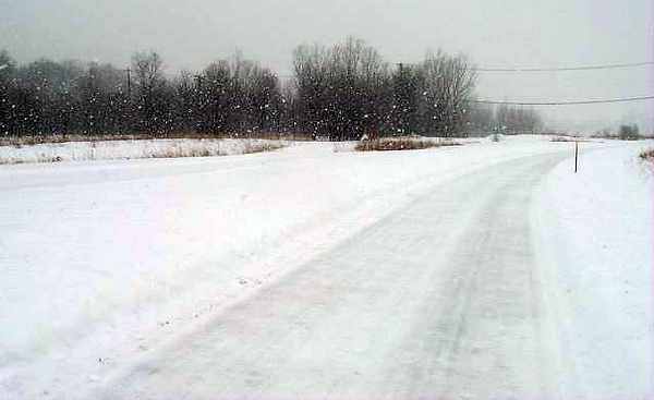
Sadly, the Twin Cities have a sprawl to rival Los Angeles. Also, the Twin Cities have several things that make a low population density easy to maintain: unlike L.A., there is no ocean bounding the growth of the metropolitan area, and no mountains. The primary geographic issue are the rivers and lakes, but most major rivers (the Mississippi, Minnesota, and St. Croix) have already been crossed by the metropolitan area, allowing growth in essentially every direction. My year-round commute is a five-day a week thing, 12.3 miles each way, from the Loring Park neighborhood just southwest of downtown Minneapolis to Eden Prairie. It's about 50% off-road mixed use paved path and 50% on road, 25% in designated bike route and 25% not. Your observations about the downtown bike lanes are apt; I don't commute through downtown but do ride for social reasons there (usually getting to Northeast or Southeast). I typically pick whatever roads will work best to get me to my destination and if there happens to be a bike lane marked on the road I may or may not use it, depending on traffic. In particular, Friday and Saturday nights on Hennepin Ave. are wacky, and when northbound I will often change from using the bike lane to using the traffic lanes depending on the traffic flow. During heavy traffic hours I am almost always faster than traffic by at least 5 mph. Both ends of the lanes on Hennepin Ave. are, as you observe, not for the timid rider; they require extensive lane changing. There is an even worse sidepath in my neighborhood Lyndale Ave. from Groveland Ave. to just short of Franklin Ave. It's about 3 city blocks long and drops you off facing traffic entering a ramp onto Interstate 94. I'll take a photo for you. Your statements about the multi-use trails aren't completely accurate. The City of Minneapolis especially and to a lesser extent Hennepin County make a distinction between what I like to call "recreational trails" and "commuter trails". Recreational trails tend to be windy, hilly, with poor visibility. They stick out as the centerline is painted green and they have a 10 mph speed limit. "Commuter trails" are much more focused on the distance commuter, with clearly marked yellow centerlines and a third lane reserved for pedestrians. These trails are limited access and, in the city of Minneapolis, are usually fenced off from the surrounding neighborhood. Most bike trails in Minneapolis are plowed quite well, but it is Minnesota. Here's a photo from a very snowy (I believe Monday) morning in February: |

| I hope that it is clear from this picture that it is still snowing and that a plow has
been over the trail at least once that morning. The commuter trails as they head through
the suburbs are less diligently maintained, but do get plowed, although often not until
after bicycle traffic as carved icy tracks which the plows can't remove. I get by for the
most part on Michelin Cyclocross mud tires. Road tires are absolutely not an option. A
friend of mine swears by a set of studded tires that he rides on in the winter while
commuting through downtown to the U of M campus. I'm planning to try them out this winter,
especially for the spring when repeated freeze-thaw-snow cycles can turn everything and
especially the bike trails into solid ice. Your review neglects to mention the Washington Ave. bridge which has existed forever which connects the East and West banks of campus much more effectively than the 10th Ave. bridge. The upper level of the Washington Ave. bridge is for non-motorized traffic only and includes marked (pedestrian-prohibited) bicycle lanes. Recently, another railroad bridge has been reclaimed between the 10th Ave. and Washington Ave. bridges which is a pedestrian/bicycle bridge very much like the Stone Arch bridge, but functions as a campus connector. I myself avoid all non-commuter trails in Minneapolis during the summer months as there is two much irregular-speed traffic to make them useful for getting places, but my same friend from the prior paragraph commutes on the Stone Arch Bridge daily. The primary problems (excluding inclement weather) for me personally as a commuter are
In general, I think the biggest problem for bicycle commuting in the Twin Cities is the design of newer roadways through the suburbs. You will often find essentially residential streets with 50 mph speed limits. These often have unworkable sidepaths. I use the road, but others just drive. Anyway, thanks for reading. I enjoy your site greatly and hope my observations help increase your knowledge of cycling in the Twin Cities. As my friends know, I'm happy to chat about bikes so I'd be happy to respond to any questions you may have for me, or not. |
| Top: Home Page Up: Minneapolis Previous: University District Previous: Bicycle Plan |
Contents © 2004, Alec Kloss |