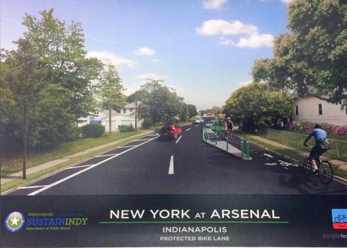
Here’s another picture from Indianapolis which I discovered online. Its geometry is slightly distorted, as it is from a screen shot. New York Street, in this picture, makes a two-way pair with Michigan Street, which I discussed in my previous post.
You may click on the images to enlarge them and get a clearer look.
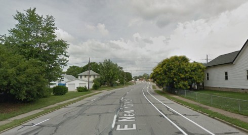
Let’s compare this with the Google Street View on which it is based:
I’m not going to discuss this in such detail as in my previous post, but please note:
- The proposed two-way separated bikeway is no more than 5 feet wide where the two bicyclists are traveling. (Compare with the bicyclists’ height and the diameter of their wheels, approximately 27 inches.) This bikeway is also between raised curbs and doesn’t even begin to be wide enough for safe two-way travel. It isn’t even wide enough to conform to guidelines for one-way travel.
- The perspective is odd. The bikeway becomes wider and the travel lanes, already barely wide enough to contain the small cars shown, become narrower in the background.
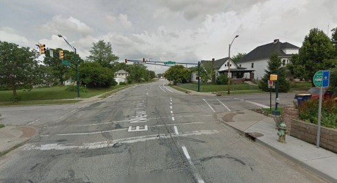
- The bikeway is described as “protected” but it crosses several driveways and, astonishingly, it opens into the street in the foreground with bicyclists facing the direction of traffic. What are bicyclists supposed to do here? Riding against traffic is illegal, aside from being highly hazardous. Here’s the view from across the intersection with Arsenal Avenue.
- Some additional trees have been added in the proposal; smooth pavement has replaced the worn pavement in the Street View, the cloudy sky has been replaced by a blue sky, and shadows have been added to simulate a sunny day. As in the picture in the earlier post, these changes create an optimistic, appealing effect, but they have nothing to do with the bikeway.
- And, again, as I asked in the other post, how is this bikeway to be cleared of snow?
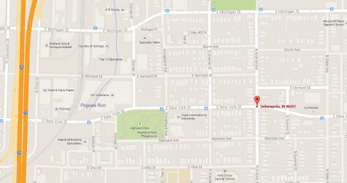
New York Street is much narrower than Michigan Street until a couple of blocks east of this point. I don’t see how there could be room for both a contraflow bike lane and a with-flow bike lane. In my opinion, two-way bicycle traffic is better accommodated on Michigan Street. A route could bypass the narrow section of New York Street by using Vermont Street, a couple of blocks to the north. That street also has an underpass under Interstate 70 — see Google map. This route would, however, require two-way bicycle traffic on reversing the one-way direction of part of N. Arsenal Avenue.
Any bike lane on the narrow section of New York Street ought to be on the left side, on the opposite side from parking: looking up and down the street in Google Street View will show that the present bike lane is in the door zone of parked cars.
Treatments at intersections should favor motorists’ merging into the bike lane before turning, and bicyclists’ overtaking turning motorists on the street side.


doubling down with another uneducated analysis of a RENDERING?
Luckily, we take much more care in our engineering than you do in your posting. We use engineering documents to build infrastructure….not renderings. Engineering a street from a rendering would be as irresponsible as, oh, I don’t know….writing about another city’s infrastructure/roadways from Massachusetts.
This rendering carries the stamp of PeopleforBikes, SustainIndy and the City of Indianapolis Department of Public Works. What is irresponsible about my commenting, if you please? I’m viewing the same image that people in Indianapolis do, I took extensive trouble to compare it carefully with existing conditions and with other possible treatments, and I proposed another treatment which, unlike the proposed one, conforms to national design standards.
JH, please submit your engineering plans for us to look at if you are so confident that the renderings P for Bs uses in its PR materials is so inaccurate. Tell us why you prefer the plans as they are as compared to the alternatives offered. Did you have specific reasons to ignore MUTCD standards?
“Engineering a street from a rendering would be as irresponsible as, oh, I don’t know….writing about another city’s infrastructure/roadways from Massachusetts.”
Hyperbole and ad-hominem attacks don’t really achieve anything here. Someone being from Massachusetts does not exclude them from being able to criticize a design (or the presentation of that design for the public).
Badly engineering a street is MUCH MORE IRRESPONSIBLE than writing a blog post. Did you even consider what your sentence means? Blog posts don’t kill people. Selling trumped-up false-sense-of-security infrastructure to city managers has very real consequences. I can’t believe I’m even writing this response to your incredibly stupid statement.
Jean-François, thanks for the support, but you did get a bit ad-hominem yourself…
Wh0 is JH and what are his/her credentials?
Still waiting for a real name from JH. If you are going to critique someone, you ought to do it up front rather than behind a screen of initials.