Most of Weston is zoned for low-density residential use. There are three major east-west corridors: Route 117, Route 20 and Route 30. Much of the area between Routes 20 and 30 is taken up by institutional uses including the Case Estate of the Arnold Arboretum; Regis College; a reservoir; and golf links. North-south corridors are on local roads of variable suitability for bicycling with low to moderate traffic volume.
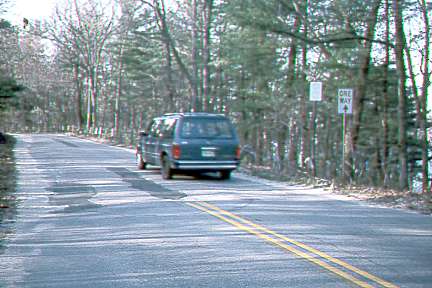
Conant Road: Between Route 20 and Route 117, this is the preferred north-south route. Traffic is very light, as the connection with Route 117 is not the best for motorists headed either east or west. Unlike Merriam Road or Lincoln Street, however, Conant Road offers a relatively safe crossing of Route 117 for bicyclists, with fairly long sightlines in both directions. Conant Road continues into Lincoln, where it joins Weston Road, providing a direct, low-traffic route to the center of Lincoln. Via Bardyll Road and Hallett Hill Road, Conant Road provides a connection to the Silver Hill commuter rail station.
Improvement as a bicycle path of an abandoned section of Old County Road branching from Conant Road north of Route 117 through a corner of Waltham into Lincoln would offer a continuous north-south route along the west side of the Cambridge Reservoir, which could continue onto the designated bicycle route on Mill Street to Lexington via an overpass at Route 2. The status of Old County Road has been an item of contention between Waltham, which would like to develop it, and Lincoln, which controls the approaches and will not allow upgrading for access to commercially zoned property in Waltham.
Lincoln has made Winter Street one-way from the Waltham boundary
to Old County Road; a contraflow bike lane, and through connection
on Old Country Road would restore two-way north-south bicycle travel.

Lexington Street provides a connection between Route 117 and Winter Street. It passes a private school. The road is narrow, and commuting traffic is heavy. An alternative is Bear Hill Road in Waltham.
Church Street provides the best on-road connection from Weston Center to Route 117 east and the Kendall Green rail station. However, parts are narrow and traffic is moderate rather than light. The disused Waltham-Hudson railbed may provide a preferable alternative (see below).
1) Treatment of the intersection of Conant Road with Townhouse Road and Church Street to reduce right-of-way conflicts. One possibility: a small island or rotary so that right-turning traffic from Conant Road does not cross left-turning traffic from Townhouse Road.
2) Designation of Conant Road as a north-south through bicycle route and Bardyll Road-Hallett Hill Road as a connecting link to the Silver Hill rail station.
3) Cooperation with Lincoln and Waltham on northern continuations of the route.
South of Route 20, the preferred north-south through route is School Street (which crosses Route 20 at a traffic light) to Wellesley Street. Wellesley Street, which passes the Case Estate, Regis College and Weston High School, is wide and excellent for bicycling except by young children. School Street is narrower, but short: adding shoulders would not be a costly project. The diagonal intersection of Wellesley and School streets would benefit from traffic islands to channelize the flow for left turns.
As it continues into Wellesley, becoming Weston Street, Wellesley Street becomes narrower. However, there are a number of possible alternate routes on back streets. These would become more practical with the addition of overpasses over Route 9 and a bicycle path on the Cochituate Aqueduct right-of-way as proposed in the report on Wellesley.
A connection from the center to the southeast corner of Weston can be made either by Newton Street or by Meadowbrook Road to Loring Road. The southeast corner, along the Charles River, is considerably downhill from the Center.
The grade on Meadowbrook Road is steady and fairly easy, with very light traffic. There are speed bumps, which should have bicycle openings and be kept painted if this is to be designated as a bicycle route. Though Meadowbrook Road is open to the public, it is at least partly on private property, and designation as a bicycle route may be a problem.
The grade on Newton Street is steeper, and there is more traffic. Newton Street, however, makes a better connection to Park Road, which leads into Newton Lower Falls.
Highland Street, to the west of Wellesley Street, is quiet and pleasant to ride, but does not connect directly with many useful destinations. Its intersection with Route 20 is unsignalized and confusing due to the diagonal entry to Boston Post Road. A safer crossing of Route 20 might be made via Chestnut Street and Golden Ball Road, a few hundred feet to the east.
East of Route 128, Norumbega Road and River Road are in Weston. Norumbega Road, an MDC road, is excellent for bicycling, though it needs a stop sign east of the Route 128 underpass and repaving in the underpass. South Street has a deteriorating bridge which has been narrowed with Jersey barriers offering hazardous passage to bicyclists.
Maintain Wellesley Street for north-south bicycle travel.
Widen School Street and install islands to channelize traffic at the School Street-Wellesley Street intersection.
Determine the status of Meadowbrook Road and if possible, designate it as a bicycle route. Modify the speed bumps. If not possible, designate Newton Street and consider adding a 2-foot shoulder, particularly on the uphill side for climbing.
Widen Park Road where it is narrow as it passes the Leo Martin Field and golf links. Most of Park Street (and connecting Concord Street in Newton) are wide enough.
Install the stop sign and improve pavement in the underpass on Norumbega Road.
The bridge on South Street should be on a priority list for repair. The Metropolitan District Commission has plans to improve the Charles River waterfront from Watertown through needham. Perhaps these would include a path along the river offering an alternate to South Street and connecting Norumbega Road with Charles River Road in Waltham.
Most of the east-west routes in Weston are numbered highways: Routes 117, 20 and 30, through the north, center and south parts of the town. Route 20 has shoulders from the east end of Weston to the intersection with Highland Street. The others have 24-foot width without shoulders.
Concord Road and Sudbury Road provide an alternate back-road route into Wayland. The major problem here is a hill on Concord road with marginal width, considering the light of the traffic volume. However, an alternate route exists via an entry to a town recreation area and an easement on drives in the Campion Center. This is a legal route for bicyclists!
1) Add shoulders to the highways. The priority is Route 20, which connects with the town center and where part of the job has already been completed.
2) Examine friendlier connections across Route 128 to the east, particularly at Route 20 (see section on off-road routes, below).
3) Improve the Concord Road route to Sudbury Road. Two alternatives are to widen it, or to develop an alternate route. One is already available via a recreational area and the roads in the Campion Center. Since the Campion Center is privately held, a designated route would probably have to avoid it.
4) Investigate opportunities to improve the Norumbega Road-South Street connection into Waltham.
Weston has a few stretches of sidewalks which appear to have been intended as bicycle paths. These are not, however, suitable for safe travel at normal bicycle speeds, and some are in disrepair.
There are numerous trails on town land and on easements through private property. One is the Campion Center route already described. Others, when suitable for through travel, will be described in this section. There are some interesting possibilities for new off-road routes, as well:
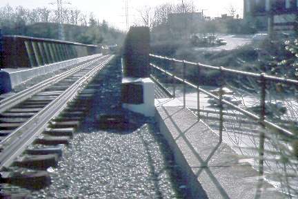
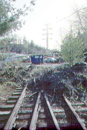
Waltham-Hudson railbed: Passing just north of the town center, this extends the full length of of Weston, and offers an alternative to Church Street and a bicycle-friendly crossing of Route 128 just east of the town line in Waltham. West of Weston Center, there is very little development along the rail line until it enters Wayland. The railroad underpass at Conant Road in Weston has been filled in rather than repaired; a new bridge would have to be built to avoid a detour and road crossing.
Waltham-Hudson rail line looking west across bridge over Route 128

Auto salvage yard encroaches on rail line at west end of bridge

Aqueducts: One enters Weston just south of Blossom Lane (south of Route 20 at the west end of town) and proceeds southeast, connecting with the Weston Reservoir. It is level and rideable at least as far as Buckskin Road, but goes underground until it reappears next to Chestnut Street. Trails exist where the aqueduct is in tunnel, but are unpaved and hilly. Level paths around the reservoir offer a legal and useful east-west connection where there are no roads. However, these are presently also unpaved, and suitable only for off-road bicycles.
A second aqueduct between the Turnpike and Route 30 might offer a useable alternative from the Wayland line as far east as Wellesley Street. Here, it crosses to the south side of the turnpike, passes through the Norumbega Reservoir and then crosses the Turnpike again. A path combining the parts of the aqueduct on the north side of the Turnpike with use of the Turnpike right-of-way might be explored as an alternative to Route 30 east of Wellesley Street, where route 30 is narrow and rather steep.
The active Fitchburg Branch rail line crosses Route 128 at Route 20. Access to the rail line is easy via Sibley Road. If a bicycle path could be run through the railroad underpass, then bicyclists could avoid the large rotary intersection and ramps from route 128 at its intersection with Route 20. There is potential here for a connection with Brandeis University and Watermill Office Park to the south, and with the Waltham-Hudson railbed to the north, and also for a path to Church Street and the Kendall Green rail station via town-owned land at the Weston dumpsite.
Recreation Road, just south of the Massachusetts Turnpike, crosses Route 128, but connects only with a frontage road at the east side of the turnpike. Directly across the Charles River at this point is the Riverside MBTA station. There are existing footbridges across the Charles River and Route 128 here which could be improved for bicycle use as part of the MDC's upper Charles River park project, offering a direct, short connection between Riverside Station and the Leo Martin golf course and cross country ski track.
The unused rail line from the Riverside station to the Lower Falls area is also being examined as part of the upper Charles River project, and provides another potentially useful connection and recreational route.
Investigate all of the off-road routes, giving priority attention to those which are shorter and bypass serious trouble spots, particularly the Route 128 crossing. Note, however, that the aqueduct south of Route 20 offers connections which are much longer on streets (Blossom Lane-Buckskin Drive-Highland Street-Regis College-Wellesley Street and continuing past the Weston Reservoir to Newton Street and Ash Street). The potential exists here for a route which would attract people to bicycling because trip times would be shorter than by car. Also see notes on this aqueduct in the Wayland report.