My history of bicycling in Vermont, and visiting Montreal, dates back to my student days at Middlebury College, in the 1960s. I have toured in Vermont in more recent years.
As long as I have known Vermont, it has had paved highways connecting most towns and cities, and well-kept secondary roads, some paved but many with gravel surfaces. The rural roads have to be kept up, and plowed promptly in winter, so milk can be trucked out from dairy farms. In my student days, I took bicycle rides on these roads even in winter — even the gravel roads were good enough to allow that.
In recent years, Vermont and neighboring New York have designated a bicycle touring loop around Lake Champlain, which lies in between them, mostly using lightly-traveled paved roads. Many stretches of Vermont and New York highways have paved shoulders, making for good bicycle touring conditions, and the Lake Champlain Bikeways loop uses them. The Lake Champlain Bikeways organization which promotes these routes and publishes maps and guidebooks. An important recent improvement has been the opening of a bikeway on an abandoned railroad causeway crossing Lake Champlain from north of Burlington, Vermont to Grand Isle, from which the bicycle touring route continues north to the Canadian border on roads. A seasonal ferry now carries bicyclists across a gap in the causeway where there was once a bridge.
A friend and I undertook a bicycle tour in August 2018 from Vermont north to Montreal, where we spent a few days, and back. This gave us the opportunity to experience and observe bicycling conditions and culture. The start of our route from Vermont north to St.-jean-sur-Richelieu in Quebec is covered on this Lake Champlain Bikeways map panel. The image of the page is here, but you may view all 7 pages of the map as a PDF at a larger sizee on the Lake Champlain Bikeways site.
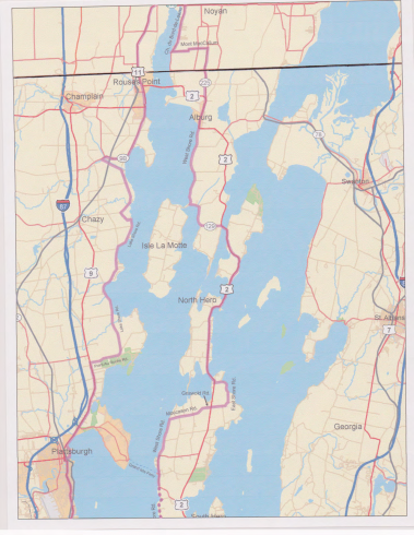
Border section of Lake Champlain Bikeways Map
Vermont’s main highways for the most part have relatively wide lanes, and paved shoulders. Here is a photo of Vermont Route 2 Just South of Alburg, Vermont, a town just south of the border with Canada.
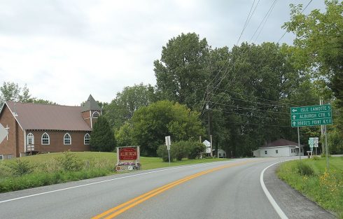
Route 2 south of Alburg, Vermont . This file is licensed under the Creative Commons Attribution-Share Alike 4.0 International license. from Wikipedia contributor RoyalbroilAlt.
The designated bicycle touring route joins Route 2 from the west in Alburg. North of Alburg, Vermont Route 225, a narrower road with very light traffic, branches off Route 2.
and heads north to the Canadian border.
North of the border crossing, Quebec Route 225 is very similar.
The northernmost section of the Lake Champlain Bikeways map shows routes north to the small city of St.-Jean-sur-Richelieu, though mostly not the route that we took.
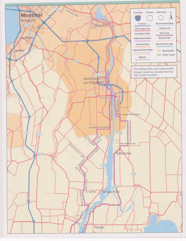
Lake Champlain Bikeways map north to St. Jean sur Richelieu
Two-lane highways in this area have narrow shoulders or are shoulderless, though they carry much more traffic. One route from Alburg shown on some bicycle touring maps turns west onto Route 202 several kilometers north of the border and crosses the Richelieu River on two bridges which are particularly vexing. There is no safe way to ride here other than to control the travel lane, possibly slowing motor traffic for a quarter mile. With the guardrail, there is no way to pull off the road and let motor traffic pass.
The second bridge is high so large boats can pass underneath. Coming down off the second bridge, where there is a narrow shoulder, I experienced my one scary incident of the bicycle tour when a motorist coming from the opposite direction pulled out to pass another and rushed past me at closing speed of over 70 miles per hour (120 km/h), less than 3 feet away. Here:
Possibly this route uses the Route 202 bridges because the roads on the west side are quieter on the way north to St.-Jean-sur-Richelieu. Also, Route 223 on the west side passes historical Fort Lennox. The roads on the east side pass through flat farmland, but there is a choice between relatively busy Route 133, which has shoulders, and smaller roads with light traffic. Some of these are used for local bicycle tours, like this one, and routes on both sides of the river are indicated on the Lake Champlain Bikeways Map.
The next bridge north, at St.-Jean-sur-Richelieu, had narrow travel lanes as of 2018 but also sidewalks. A new, much wider replacement bridge was under construction in 2018 and should be complete by 2020 -maybe already in 2019.
Route 202 over the bridges is indicated as a bike route on some maps, but the official Route Verte #2 enters Quebec from New York State, on the west side of Lake Champlain. I recommend taking the Grand Isle-North Hero ferry from Vermont to New York if you are going to ride up the west side of the Richelieu River. The Route 2 bridge over Lake Champlain is long and high, but it has shoulders. The ferry is more enjoyable.
North of the border crossing on the west side of the lake, Route Verte 2 runs for a few kilometers on Quebec Route 223. It has narrow shoulders but it is relatively straight, very flat and carries light traffic. A parallel limited-access highway is the main route to Montréal.
Route Verte 2 turns left off Route 223 onto local roads north of Route 202, but we stayed on Route 223 because we did not have the official map and weren’t certain whether the left turn would only go west rather than north to St.-Jean-sur-Richelieu. Also, the Fort Lennox historic site on the Richelieu River is accessible from Route 223. Reaching Fort Lennox would require a detour from Route Verte 2.
Approaching the St.-Jean-sur-Richelieu, about halfway between the border and Montreal, Route Verte 2 rejoins Route 223. We were surprised to find a cyclist in full spandex kit, on en expensive road bike, salmoning toward us (riding facing traffic on the left side of the highway). Where we live, in the USA, novice cyclists salmon; people who wear expensive bicycle clothing and ride fancy road bikes do not.
A few miles farther on, Route Verte 2 leaves highway 223, turning onto a two-way one side of the street, paint-separated bikeway alongside a two-way, two-lane road, the old highway that went through the middle of St.-Jean-sur-Richelieu.
This, to me, offered an explanation for the behavior of the spandex-clad salmon we encountered: if riding on the left side of the street is OK where paint stripes prescribe it, then it must be OK elsewhere too.
Here is the turnoff from Route 223 as it looked in June, 2018
And here, in June, 2009.
The Québec bicycling advocacy organization Vélo Québec has complained about a cut in funding for maintenance, and it has a point. But this organization also promotes some rather, well, unusual bikeways. These bikeways do not reflect either a bicycles-as-vehicles approach or European design for separated bikeways. The contrast between Route 223 and the bikeway into St.-Jean was jarring.
The paint-separated two-way bikeway continues most of the way into the center of St.-Jean-sur-Richelieu. Where there has been repaving, even the paint stripe gets obliterated.
Riding northbound, the direction of these Street View images, is like riding in an ordinary bike lane, except when confronted with oncoming bicycle traffic. The southbound bicyclist is instructed to ride on the left side of the road and closer to the oncoming traffic. There are issues of conflict with oncoming, turning and crossing bicycle and motor traffic..
Parts of the bikeway into St. Jean sur Richelieu are sidepaths separate from the roadway.
As my friend and I headed north, these were the first examples we found of what I call “separation by any means necessary”. In the USA, there is a lot of noise about “protected” bikeways — bikeways separated from motor traffic by parked cars or a barrier. These don’t protect at intersections, where most urban crashes occur. The Québec paint-separated two-way bikeways offer questionable separation and less than no protection, even between intersections. We got to see a lot more of them and other oddities and also some impressively good infrastructure as we continued our trip. Return to the post that introduces this series to move on to the next segment of our trip.