How would I like to think of the People’s Pike? I want to see a bicycle path and an adjacent footpath which avoid crossing and turning conflicts, passing under the ramps to the Turnpike and to the proposed West Station, with connections up to the overpasses to get to West Station and beyond, to Packard’s Corner and the Boston University campus.
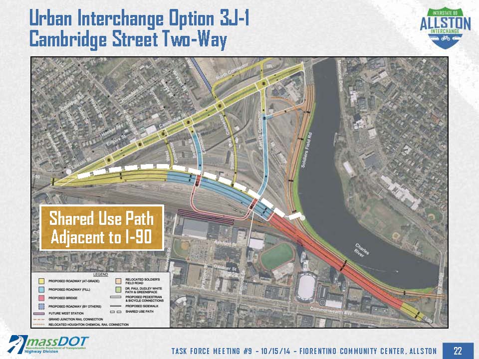
Early proposals for the People’s Pike all showed it running parallel to the Turnpike where it could go under the ramps, but at the October 15 Task Force meeting, I saw three proposals for a bikeway through the project area. One proposal was for a route near the Turnpike. It would provide a direct connection between North Allston, West Station and the Paul Dudley White path, and it would have grade-separated crossings of least two– maybe all– of the four streets which lead to the Turnpike and West Station.

The MassDOT presenters somehow thought that this would be a bad idea: the path would be next to a retaining wall, and there would be noise from the Turnpike.
I don’t understand why noise would be a major problem. The retaining wall would reduce the noise, as the Turnpike would be up on an elevated structure for much of the route. Also, there’s been a lot of discussion of noise barriers, and I don’t see why the path couldn’t be pulled a bit farther from the Turnpike. For purposes of comparison, you might take your bicycle out onto Lincoln Street in North Allston. It runs alongside the Turnpike. There’s a noise barrier along part of Lincoln Street too , in case you would like to check out how that works.
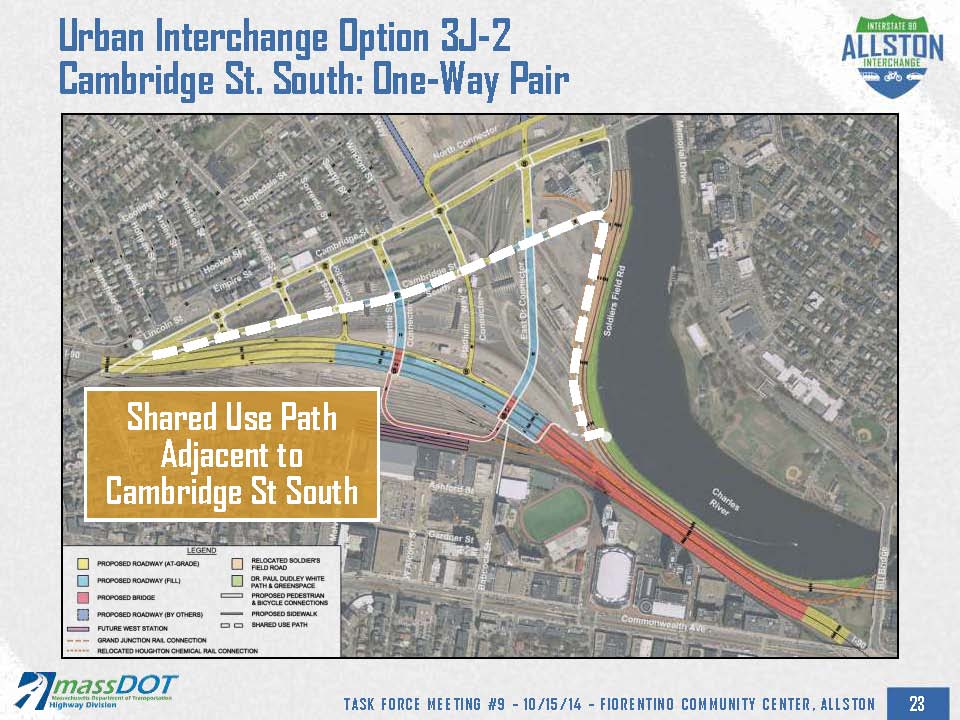
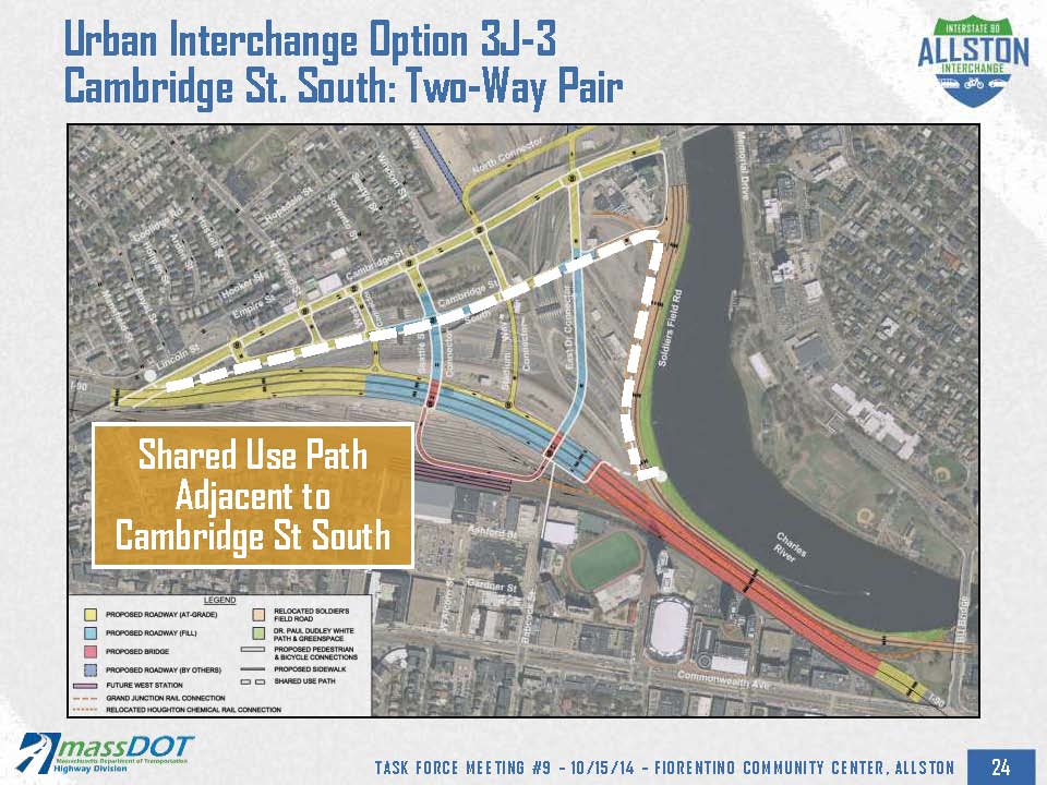
Two other proposals were for paths alongside a new Cambridge Street South.


Somehow, the presenter at the meeting seemed to think that if there is a Cambridge Street South, then the bikeway has to run alongside it. But why, and what sense does it make for the bikeway to take that route — granted, that bicyclists making local trips will still have to use Cambridge Street. But is this a People’s Pike?
As shown in the overhead views, the route would follow the new Cambridge Street South down to Soldiers Field Road, turn more than 90 degrees, and go alongside Soldiers Field Road for a quarter-mile before crossing over to the Paul Dudley White paths. This is a 40% longer route, and need I say that Soldiers Field Road also is noisy? Also, there would have to be spurs to connect to West Station and Packard’s Corner. Trips between North Allston and those locations would be longer. (If you look carefully, you can see an additional Turnpike overpass in the drawings, to shorten the trip from the PDW path to West Station).
There are also other serious issues with travel time, and with safety.
All of the traffic to and from the the Turnpike and West Station, including heavy trucks and buses, would cross or turn at Cambridge Street South.
So, let’s consider: what is a cycle track? Simply stated, it is a bicycle path next to a busy street. Traffic in the cross streets crosses it. Traffic turns across it at every intersection and driveway. Signals at the intersections delay bicyclists. The delay makes the trip more inconvenient for people who are careful, but it makes for trouble for people who are less cautious or who don’t understand the hazards. At the driveways, there are no signals, and turning motorists must be extra-careful to avoid colliding with through-traveling bicyclists. Sometimes sight lines are blocked and it in only safe to inch forward. Not everyone does that.
In urban areas, turning and crossing collisions are the largest cause of serious and fatal bicycle crashes. The same issue can occur with a bike lane, or with a cycle track. If you think that a bikeway alongside a roadway rather than on it solves this problem, you might consider the many bicycle-motor vehicle collisions at street crossings on the Southwest Corridor path where it runs alongside Washington Street.
The Cambridge Street South proposals appear to be for a two-way bikeway on one side of the street. This design poses the greatest dangers, because bicyclists arrive from more, and more unusual, directions.
There’s a noise and air quality issue too. Where there is a cycle track, there is an adjacent sidewalk, but the cycle track is always closer to the street traffic, and it’s at street level.
On the other hand, the parallel path proposal which would take the People’s Pike under the ramps would work for bicyclists at all skill levels, even children. The path need not be chock-a-block with the Turnpike, either, because a bicycle underpass only has to be 10 feet high, while a Turnpike underpass has to be 17 feet high.
The MassDOT proposals with a path alongside the Turnpike would still have it cross two streets at ground level — as opposed to the four crossings (plus who knows how many driveways) for the Cambridge Street proposals, and the one crossing in the Boston Society of Architects proposal formerly here on Facebook.

But let’s think big here: let’s think underpasses at all cross streets. The blank slate for new construction in the Beacon Yards area offers unparalleled flexibility in planning and design, and let’s take advantage of that.
Let me just put the question in the boldest terms: What do you want: a direct route between North Allston, West Station and the Charles River on a path with no street crossings, somewhere near a busy Turnpike frontage road and with the possibility of a noise barrier; or an indirect route alongside busy Cambridge Street and Soldiers Field Road, crossing four or five intersections with heavy motor traffic including bus and truck traffic, and who knows how many driveways?
Call it what you will, but only the one which avoids the cross traffic is a People’s Pike. The other proposals are People’s Pillar to Post, as far as I’m concerned.

Leave a Reply
You must be logged in to post a comment.