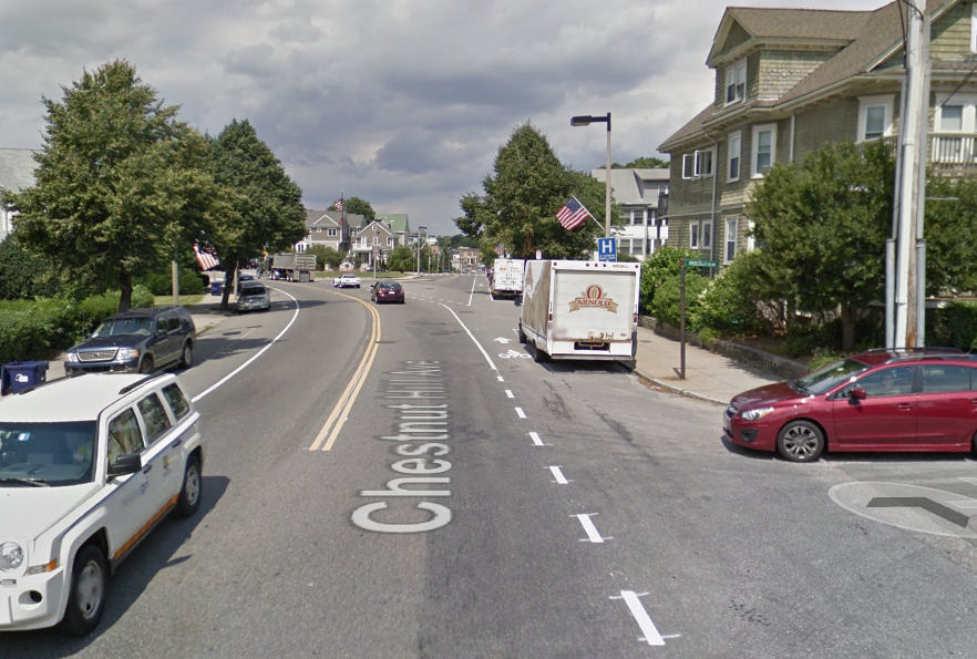
How many hazards can you see for a bicyclist in the location shown in this Google Street view?

A bicyclist in the bike lane in the camera location would just be appearing to the driver of the red car from concealment by parked cars (behind the camera), risking a motorist drive-out. A motorist behind the bicyclist also could attempt a right turn into the street with the red car. The bicyclist would also be in the door zone of those parked cars and in the next block, assuming that the red car hadn’t driven out, would be at risk of doorings and additional drive-outs — there’s a driveway just past the lamppost with the American flag; also right turns into the driveway. The bicyclist, if bearing left to continue on Chestnut Hill Avenue, is directed by a dashed bike lane to continue across Winship Street at a lw angle from right to left. Winship Street is nearly straight ahead and a motorist continuing on Winship Street has no need to slow down. So, the bicyclist following the markings faces a gauntlet of hazards.
But actually, that was a trick question. A bicyclist riding in the lane the position shown in the picture wouldn’t face those hazards. A motorist coming from behind would have to wait for a safe opportunity to overtake — which would occur in about one second, once the white Jeep had passed, if the motorist merged across the double yellow line, as most do and as is now legal in Massachusetts [update, as of 2023] when overtaking bicyclists, as it is in several states — or else wait until the bicyclist passed Winship Steet and could safely merge into the bike lane.
Other examples:
Harvard and Western: https://goo.gl/maps/hvK4j
Warren Street, Charlestown: https://goo.gl/maps/Is3Ap Also Main Street

Leave a Reply
You must be logged in to post a comment.