
[Note: I’ve changed the title and a few words in this article, because a reader has pointed out the the drawings I’ve commented on, while approved by PeopleforBikes, are not from PeopleforBikes — the impression which an article I cited gave. Nobody has explained as of yet who did the drawings.]
This article critiques a proposed treatment for Michigan Street in Indianapolis, Indiana. Indianapolis is one of four cities which have been targeted for grants by the advocacy organization PeopleforBikes — whose financial support and agenda, let it be clear, and despite its name, are from the bicycle industry.
It’s only fair for me to criticize if I can suggest a better alternative. But first let’s look at existing conditions on Michigan Street
Michigan Street approaching Keystone Street in front of the Thomas Gregg Elementary School is shown in the Google Street View below, from July, 2011.

Michigan at Keystone, October 2011
Michigan Street presently has a bike lane, visible behind the car in the Street View image. (The car is straddling the bike lane, having given the Google camera car a wide clearance when passing on the right.) The door zone placement of the bike lane creates hazards which reinforce the impression among uninformed people that the government has done the best it could, short of constructing a sidewalk-type bikeway. There are cars parked adjacent to the bike lane in the next block.
Other Street Views show a small number of cars parked on both sides up and down the street. An earlier Street View, from July 2009, shows how the leftmost lane was narrowed and the other lanes were shifted over to make room for the bike lane on the right. You can see the lane lines which were blacked out.

Michigan at Keystone in 2009
The left lane was already used for parking before it was narrowed, but now its narrowness, along with the parking, makes it hardly useable for travel.
Taking a larger look at the neighborhood (see Google map) —
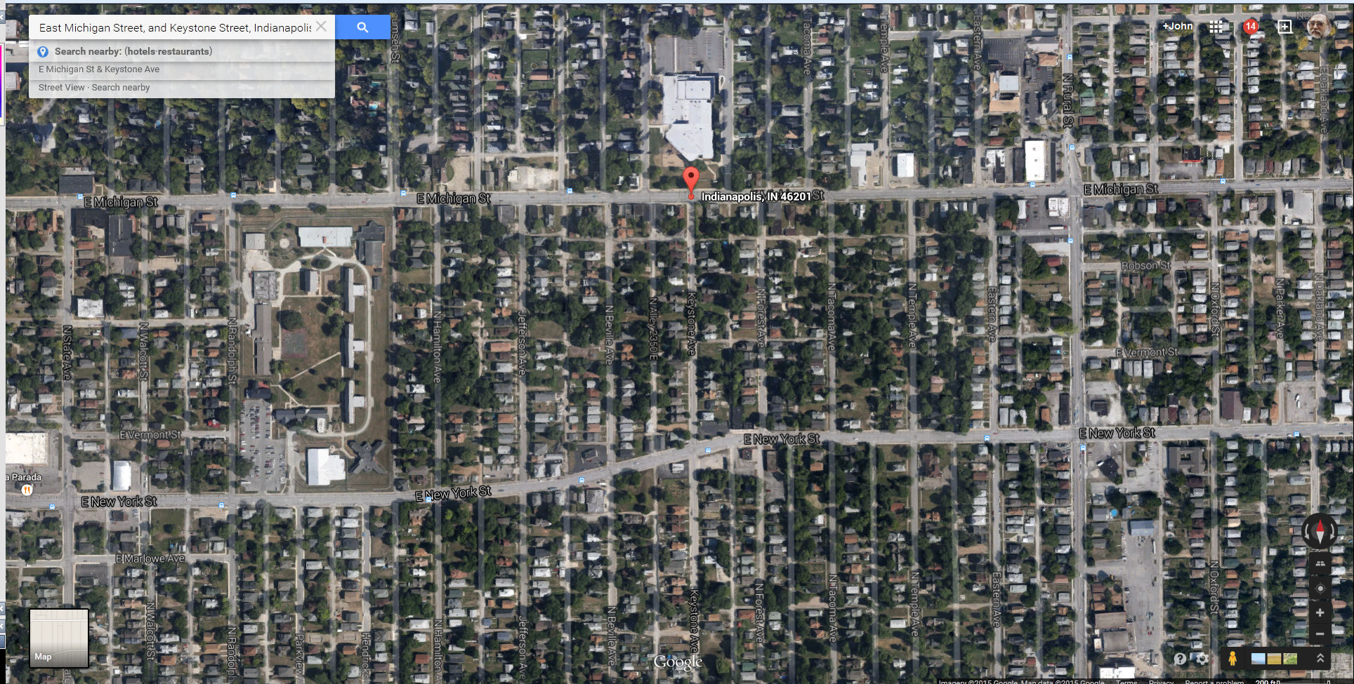
Google Map of East Indianapolis
Michigan Street is half of a one-way pair, with New York Street, a block to the south. These are arterial routes in and out of the city center, which is to the west. Traffic is very light in Street View images, but it must be heavier during the morning and evening rush hours. The long north-south blocks make wrong-way local bicycle travel on these one-way streets tempting. There is a bike lane on the right, intended for one-way travel.
What, in my opinion, is the best which could be done here to provide for local bicycle travel in both directions?
Let me suggest that making the leftmost lane of each of these streets into a contraflow bikeway would provide for two-way bicycle traffic, with the low stress which would be attractive to novice and casual bicyclists, while maintaining a normal and expected pattern of traffic movements: the streets would be one-way for motorists and two-way for bicyclists.
This would remove parking on one side of the street, but is parking an issue here? Because the blocks are long from north to south but short from east to west, there are many more available parking spaces on the north-south streets than on Michigan Street and New York Street. The small number of parked vehicles on Michigan Street in the Google Street views suggests that removal of parking on one side of the street would not result in parking overflow. Even for deliveries, the blocks are so short that parking around the corner on a north-south street would not be a much of a hardship.
There is still a concern with this idea, that some bicyclists would ride opposite the flow of traffic in the contraflow bike lane. That issue can be addressed by also having a with-flow bike lane on the left side. Then bicycle traffic adjacent to the motor traffic is traveling in the same direction, and the opposite-direction bicycle traffic is closer to the curb, conforming to the normal traffic pattern and expectations. Here’s an example of this type of treatment, from Fresh Pond Park in Cambridge, Massachusetts:

This is a treatment approved for the Manual of Uniform Traffic Control Devices, the national standard reference. In the standards-setting document describing contraflow bicycle lanes, note the wording:
Where used, a contraflow bicycle lane should be marked such that bicyclists in the contraflow lane travel on their right-hand side of the road in accordance with normal rules of the road, with opposing traffic on the left…
A bicycle lane for travel in the same direction as the general purpose lanes may be placed on the left hand side of the general purpose lanes.
Appropriate use of short median strips before intersections could direct motorists to merge into the with-flow bike lane before turning left, but prevent them from merging into the contraflow bike lane, and with minimal impediment to plowing..
There is adequate width on both Michigan Street and New York Street to install this treatment, while still having two through travel lanes, as well as parking and bus stops on the side without bicycle lanes.
I’m not saying that this treatment is ideal. There are still issues with motorists turning across the bikeway and entering form side streets. However, the normal and expected pattern is maintained, with traffic keeping to the right. The one-way street becomes a two-way street, except that only bicycle traffic may travel in one of the two directions.
It might be desirable to reverse the one-way pattern if more trip endpoints and connecting routes are on the side of the street which would be opposite the bicycle lanes, and to place the morning rush-hour traffic on New York Street to get it away from the elementary school.
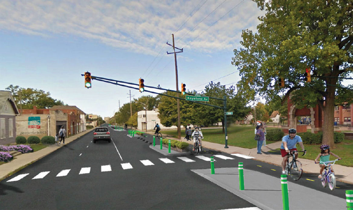
Now let’s see what PeopleforBikes is promoting.

Photoshop drawing of proposed Indianapolis bikeway
The article which includes the Photoshopped illustration above makes the following statement:
Leaders with the national organization People for Bikes said protected bike lanes are like “sidewalks for bikes” and Indianapolis needs more of them.
It’s hard enough to overcome people’s false sense of security about bicycling on sidewalks without having to fight the bicycle industry’s Astroturf advocacy organization!
The statement, and the soothing but inaccurate term “protected bike lane”, take advantage of the incorrect and often fatal misconception by casual cyclists and parents that sidewalks are safe places for bicycling. Decades of research show that bicycling on sidewalks produces a crash rate higher than on streets, and also show that barrier-separated on-street bikeways are appropriate, preferable and reasonably safe only under a limited range of conditions and with the application of strict design standards which make them very different from sidewalks. In spite of all this, barrier-separated on-street bikeways are by and large the only thing which PeopleforBikes promotes. And here, it’s promoting them by ringing the bell of the public’s fondness for sidewalk cycling.
But, to get down to specifics, how realistic is the PeopleforBikes promotion? To what extent does it reflect applicable and appropriate standards?
Let’s look at the reality factor with the image in general.
Below is a comparison of the Google Street View from October, 2011 with PeopleForBikes’ the Photoshopped image. You may click on it to enlarge it and get a clearer view.

Google Street View of Michigan at Keystone compared with PeopleforBikes Photoshopped image
The school building at the right side is identical, but the other elements of the original image have been enlarged to shift them forward: the traffic signal and utility pole, buildings on both sides of the street, even the clouds in the sky. The burned-out building on the left is now out of the picture. The worn pavement and faded lane lines of the street have been replaced with a smooth, clean, constant color.
The original Street View shows a blighted neighborhood, heartbreak of the American heartland. and if you open up Street View and look around, you’ll see a number of buildings with boarded-up windows. In the Photoshopped image, the neighborhood is nicely spruced up.
Changing the ambiance creates an air of optimism and helps to sell the bikeway, but on the other hand, the Photoshopped realignment of the streetscape makes this into a fantasy image, not a depiction of any possible future reality.
Now let’s examine the street layout.
PeopleforBikes The artist has placed the street segment which goes off to the left outside the Photoshopped image. The crosswalk in the foreground appears to be in mid-block, unless you notice the traffic signal mysteriously hanging in a tree at the right, its supporting post outside the picture.
Another look at the PeopleforBikes image
The image below is a composite, with a part of the Photoshopped image (area with darker pavement) pasted over the unaltered one, and showing the changes in lane widths. The car at the right is the real one from the unaltered image, and the more distant car is Photoshopped. PeopleforBikes The artist has made all of the travel lanes as narrow as the leftmost one. Again, you may click on the image to enlarge it and view it more clearly.

A comparison where the enlarged parts of the image are matched
The next comparison reveals some issues with dimensioning. I have brought the image of the car in the Photoshopped drawing forward and enlarged it in proportion to the lane width to compare it with the real car. The Photoshopped car is way too big. Also, I have drawn a red line extending forward from the curb line in the next block. That curb line leaves too little width for the right-hand lane — already very narrow — to continue. Assuming that the travel lane in the Street View image is the usual 12 feet wide, PeopleforBikes The artist has reduced it to approximately 9 feet in the nearest block and to 4 feet in the next block — but without any indication that drivers must merge. Because the left lane is used for parking, then only one lane remains usable for through travel.

Comparison of car sizes
Next, let’s look at the width of the bike lane and proposed separate bikeway.
The near-horizontal red line in the image below extends from one side of the street to the other along the edge of a crosswalk. The other red lines which cross it define the boundaries of travel lanes, a traffic island, the bikeway and the right-hand sidewalk.

Comparing widths
If we assume that the right-hand and middle travel lanes in the unaltered image are the typical 12 feet wide and the sidewalk is 5 feet wide, then the two-way bikeway is also about 5 feet wide. This is very tight even for a one-way bikeway. The minimum for a two-way bikeway according to AASHTO [American Association of State Highway and Tranportation Engineers] guidelines 10 feet, preferably with rideable shoulders, and 12 feet are recommended. A 5-foot-wide bikeway between the curb at the sidewalk on one side and a traffic island at the other guarantees congestion, head-on crashes and diversion falls at curbs. Small children and novice cyclists, especially, don’t have the skill or judgment to ride safely under such tight conditions.
But in addition, it might be asked what is the purpose of the 8-foot-wide traffic islands (wider yet in the next block), when the bikeway next to them is only 5 feet wide — and why a two-way bikeway has been placed on the right side — which is the wrong side — of a one-way street.
Finally, let’s look at the only street intersection visible in the Photoshopped image. It is in the deep background. The image below is blurry because it has been enlarged.

intersection in background of picture
Motorists turning right from Michigan Street must cross the bikeway, looking both right and left, and backing up traffic, and then also yielding to traffic on the sidewalk, likely blocking the bikeway. Motorists entering Michigan street must yield first to sidewalk traffic, then to traffic on the bikeway, blocking the sidewalk, and then to motor traffic, blocking the bikeway and possibly also the sidewalk. The white building on the corner hides motorists and bicyclists approaching from the right from each other — already the most hazardous conflict. The proposed solution to this problem is to paint the pavement in the conflict zone green.
In my proposal with bike lanes on the other side of the street, motorists would block the sidewalk when waiting but would cross both the contraflow and with-flow bike lanes in one move, as is usual when making left turns.
And, I might ask, how would this complicated layout be cleared of snow in winter?
Let me summarize: PeopleforBikes has created put its stamp of approval on a pretty picture which doesn’t reflect anything real or workable,. This production amounts to a shameless propaganda effort reminiscent of old Soviet publications where images were altered to airbrush out people who had fallen out of favor. The design-by-Photoshop effort shows a profound lack of understanding of, or concern for, issues as fundamental as the necessary width of a general-purpose travel lane, or of a bikeway, or the hazards of wrong-way riding.
Well done!
Wow…..you really spent a lot of time making incorrect assumptions from a rendering. This was taken from the engineering documents. If that rendering (not developed by People for Bikes) is Soviet style propaganda…..well, I guess your post is representative of the kind of sensationalistic and uneducated reporting that we might find on cable news. Why have the faded pavement makings been replaced with fresh color? Wait for it………the section of road is being resurfaced and new thermoplastic pavement markings will be replacing old paint.
“If we assume that the right-hand and middle travel lanes in the unaltered image are the typical 12 feet wide and the sidewalk is 5 feet wide, then the two-way bikeway is also about 5 feet wide.”
Exactly….you are assuming. These will be 10 foot travel lanes. The two-way sections will be 10 feet wide.
I have never looked at your blog before this….but if all the other posts are as unchecked and inaccurate as this…I can’t imagine I am missing anything.
It seems like my post is going through a bit of Soviet-style censorship.
Another point. Your “alternative” to place the facility on the opposite side of the street. How do you propose addressing this facility continuing as a one way standard bike lane east and west of this project’s limits?
How would a facility on the left side of the street continue as a one-way standard bike lane? As a one-way standard bike lane on the left side of the street, with bus stops and parking on the right side. The issue is with terminating the contraflow travel. The contraflow section would have to end at an intersecting street at both ends.
If the street becomes two-way, there is also an issue with transitioning the right-way bicycle travel to the right side…I’ve looked at the map and Michigan Street goes on for miles one-way east and west. No big problem at the east end where it’s a two-lane street in a residential area. Going west, it passes all the way through the center of the city, where the left side is preferable, until it crosses on a bridge over the White River. I’d suggest signal timing at some point near the White River so bicyclists can merge across between platoons of motor traffic.
“Why have the faded pavement makings been replaced with fresh color? Wait for it………the section of road is being resurfaced and new thermoplastic pavement markings will be replacing old paint.”
Well, of course. But I said that in the context of the drawing in which buildings have been moved, the nearest intersection is outside the picture, and the more distant one is too far away to see clearly. As a rendering, or concept drawing, the image is intended to depict and promote the project. To succeed in that, it must withstand criticism. Putting a smiley face on a project and concealing difficulties doesn’t sell to me or to anyone else who has a discerning eye. If whoever did the drawing knew that the two-way bikeway sections would be ten feet wide, then the drawing should not be so inaccurate that they appear 5 feet wide. If a travel lane is 10 feet wide, it should not appear 5 feet wide. The illustrator’s use of perspective to move buildings is impressive, so these dimensional errors are perplexing.
Aside from these issues, there is a two-way bikeway on the wrong side of a one-way street, and 10 feet between curbs is still narrow. These issues cannot be dismissed as interpretation of a rendering, as opposed to a design drawing. Rather, it is important to address issues such as this before design goes forward, and that is what I have attempted to do.
Correction pending: the drawing is not by PeopleforBikes, though PeopleforBikes approved it: the logo is not only under the picture, it is Photoshopped onto the side of a building in the picture, and the statement about sidewalks for bicycles is cited from PeopleforBikes. May I ask, who did the drawing?
And I didn’t ask the rhetorical question, why have the worn pavement markings been replaced. You did.
Hey, John. A few brief replies:
1) It’s a pretty rough image, I believe intended to convey the concept more than the actual dimensions. According to the city, the bidirectional section of the bikeway will be 10 feet wide (5 in each direction) and the one-way sections 8 feet wide to allow sweeping and snow plows. The general travel lanes are being narrowed to 10 feet, which seems standard for an urban environment and certainly much safer than 12 feet.
2) I think the “enlargement” you mention is also known as “using a photograph taken from a slightly different angle than the Google Street View shot.”
3) On the “sidewalks for bikes” phrase, it seems to me that the phrase embeds a pretty clear suggestion that sidewalks as we know them are not for bikes. Getting bikes off of sidewalks is of course a big reason physically protected facilities are needed on many streets.
Comments in response to your replies:
The proposed treatment is unnecessarily complicated and hazardous, and inconvenient for users. A two-way bikeway on the left side of a one-way street is approved for the Manual of Uniform Traffic Control Devices, as I mentioned, and greatly reduces the conflict potential compared with one on the right side, as proposed.
The geometrics of the drawing are very sloppy. They don’t show anything near the proposed dimensions. Not good enough.
10-foot lanes slow down traffic the same way the narrow streets and piles of snow here in the Boston area do: by making driving more stressful. There are generally fewer serious crashes, but as comparisons of Massachusetts crash records with those of other states show, there are more fender benders. The narrower lanes and slower traffic do increase safety for pedestrians crossing the street. The side mirrors on a city bus or large truck overhang a 10-foot lane, see this. A safer street, as I see it, is one with clearances which don’t turn minor driving errors into fender benders, and used by safe drivers. Safe driving is a licensing and enforcement issue, one which which this nation has largely failed. I see narrowing the streets as a hardware solution to a software problem.
The enlargement is an actual geometric enlargement from the same photo, not a photo from a different angle. In my comparisons, I overlaid parts of the proposal image on the original Google Street View, and they fit perfectly.
I think the ball is still in your court–what is the reason P for B prefers the proposed configuration over the MUCTD-approved configuration?
Micnael, though I am dismayed with PeopleforBikes putting its stamp of approval on seriously-flawed project, I truly appreciate the civility of your comments.
First, do we have an idea of what the vehicles per day are on this street? I recall seeing a pic of Genesee Street in East Buffalo over on Streetsblog and it was also quite empty in the picture. Possibly because of a lack of commerce and urban blight. When I was a kid, that street was bustling. I would estimate a good third of the houses on the street I lived in as a little kid, Johnson Street between Genesee and Sycamore, are now empty lots based on a Google Maps aerial view.
So a couple things. One, perhaps traffic is so light that adding a protected bike lane is unnecessary. Or, that traffic is so light that sacrificing a lane and adding a separate facility would not reduce level of service. That still means the facility has to be built properly so as to protect at intersections and curbcuts, allow plowing, avoid head on bike crashes, etc. If there are too many intersections and curbcuts, it seems to me a protected facility isn’t really very protective.
That all said, one has to ask if the neighborhood would use it. Would it connect homes to workplaces? Schools? Are people of the mindset to use bikes?
He seems to be withholding my post(s) on this. Why you would keep a post from someone who actually lives in Indy, uses these corridors daily…..and happened to be involved with the actual project in the hopper is a mystery to me.
I guess I wouldn’t want my inaccuracies pointed out either. It looks like he took a long time to come to such a flawed conclusion.
Who seems to be withholding your posts? which posts? Oh, I get it. I hadn’t reviewed new comments on my blog since earlier today and at that time I only looked at the ones from people who had commented earlier. Though you posted your first comment a couple of days ago, I didn’t get any e-mail announcements of your comments till this afternoon, and I didn’t review your comments till just now. Like most bloggers, I review comments by first-time commenters in order to weed out spam and obscenity. If you look back though my posts, you’ll see that I welcome criticism. Welcome aboard, but please, Soviet-style censorship?
Perhaps you would like to supply the engineering documents you refer to which may be fruitful to the discussion. I am sure that you want the project to have the best results it can. What do you think of Mr. Allen’s alternatives, as compared to the plan you are working with. Why, specifically, in terms of level of service and safety, do you prefer certain features over others?
I looked through many Street Views while preparing my post. In a Google Street View from 2007, I saw two bicyclists: one riding with traffic on the left sidewalk and the other opposite traffic on the street. In one other Street view, I saw a bicyclist waiting on a corner. I don’t know what the traffic volume here is, though the street’s being inbound to the center of the city while bordering an elementary school points out special safety concerns with its being designed as a speedway. I have little doubt that a facility would increase the appeal of the street for bicycling, and especially for local school and shopping trips, but a bikeway must be designed well if it is also to have acceptable safety and level of service.
Pingback: Another pretty picture from Indianapolis | John S. Allen's Bicycle Blog
The 2009 photo of Michigan at Keystone is a montage. The split can be seen on the cross-arms of the telephone pole just beyond the white building in the medium distance on the right side of the street. It extends up to the horizontal arm of the traffic signal and can be followed down to the pavement and can be seen in the crosswalk stripes if you know where to look. It was apparently placed just beyond the start of the bike lane. It doesn’t appear that the split was placed to insert additional width, but if you look at the building in the near distance on the left, you will see that the use of two shots introduces camera parallax that augments the “widening” effect of foreshortening as you move closer to the camera. In other words, it acts like a mild fisheye lens. There’s no doubt that the lanes were shifted over between 2009 and 2011, but unless you go out there with a wheel and roll off those distances, I don’t think you can scale off the distances that finely from a comparison of those two photos, although I admit the rendering does throw down an awful lot of island without appearing to take it from anywhere.
Bruce — that is an unaltered Google Street View: you can compare it with the same one on the Google Maps site. There was no intention to doctor the image. I certainly didn’t. It’s just that all Google Street views have breaks of this kind resulting from the slightly different locations of cameras which point in different directions. Any two cameras can be made to line up only when objects are at a particular distance (usually, far away and the discrepancies become worse closer to the camera). The cameras also can become slightly misaligned, as is probably the case here, where the images of the distant telephone pole don’t line up. The same issue occurred with old Cinerama 3-strip panoramic movies. (still can be seen in two theaters, by the way: one is in England, the other in Seattle).
The misalignment does add about 6 inches, maybe as much as 1 foot to the middle lane in the foreground, but if you compare it in front of and behind he split, you can see how much (especially in the large image on the Google site). The main thing that was done with installation of the bike lane which is visible in the 2009 photo was to narrow the left lane. The lane stripes either side of the middle lane have been moved over by an equal amount.
By way of contrast, Microsoft Bing images I’ve seen use some kind of a camera that shoots a full 360 degree image without and match lines. I think Microsoft must do it with a super wide-angle (more than 180 degree) lens and digital correction of the distorted (anamorphic) image. But Google has coverage of many more streets than Bing.