Forbes Magazine and “protected bike lanes”

I have submitted the comments below to Forbes Magazine, whose blog posted an article titled “Spotted Those New Protected Bike Lanes? Get Ready for More.”

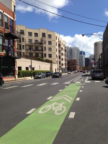
I expected better of Forbes, a generally conservative publication. The term “protected bike lane” is used only to describe an on-street bikeway behind a barrier, but Forbes illustrated the article with a photo of a buffered bike lane. There is no barrier in the photo, only paint.

Forbes thinks this is a "protected bike lane". It is a buffered bike lane.

Forbes thinks this is a “protected bike lane”. It is a buffered bike lane.

My comments follow.

************

A few clarifications:

* The bike lane shown in the photo is not a “protected bike lane”. A “protected bike lane” (see below for why I use the quotes) is separated from the rest of the travelway by a barrier, which could be a curbed median island, a row of parked cars, or a row of delineator posts. What is shown is a buffered bike lane, separated from another lane by a painted strip which is wider than the standard lane stripe.

* This buffered bike lane is separated from the adjacent travel lane, but adjacent to a parking lane, and directs bicyclists to ride within the range of opening car doors. A bicyclist who strikes an opening car door is flung to the left, potentially going under the wheels of an overtaking motor vehicle.

* A buffer may on the other hand separate the bike lane from the parking lane. This is safer.

* The inaccurate term “protected bike lane” is used with the goal of promoting increased bicycle use, pandering to widespread misconceptions about safety, and in particular, the belief that the most important type of bicycle crash is for a bicyclist to be rear-ended by a motor vehicle. This type of crash is rare in urban areas.

* The term “protected bike lane” is incorrect and misleading. Being separated by a barrier, this is not a lane, it is a bicycle path. Also, it is protected everywhere except where that matters most: at intersections and driveways, where most motor-vehicle-bicycle collisions occur, and conflicting movements forced by the barrier (car turning right from left lane, bicyclist in right rear blindspot of motor vehicle, or concealed by parked vehicles) increase the risk.

* Typical safe average speeds on “protected bike lanes” are 5 miles per hour, increasing the temptation to take risks and disobey the law.

* In some cases it is possible to have a separate bikeway in a street corridor which avoids the problems, but this is unusual and requires careful designs. One example is with 9th Avenue in New York City; please see comments linked at http://john-s-allen.com/galleries/NYC (and for a counterexample, see the comments on the Grand Street bikeway linked from the same page.)

* Other options such as conventional bike lanes of adequate design, paths separate from roads, bicycle routes on lightly-traveled streets paralleling main streets, traffic speed reduction measures, enforcement and education avoid the problems with barrier-separated bikeways. However, barrier-separated bikeways are being heavily promoted and widely installed, because of the public misconceptions about safety and the clamor of bicycle mode share advocacy.

I am a long-time bicycling advocate and it pains me to see the state of bicycling advocacy today; also, the shallowness of media coverage, and yes, this article is an example. If Forbes can’t even get terminology right and call out inaccuracies and distortions, it is only contributing to the problem.

Posted in Bicycling | 7 Comments

M. Kary’s comment letters to Injury Prevention, unedited

The journal Injury Prevention published two responses (eLetters) by M. Kary, Montreal mathematician and cyclist, to the Harris et al. study of Vancouver and Toronto bicycle facilities. These letters promised an eventual third letter. Instead, following discussion with the Editor, the third was transformed into a longer Commentary now under consideration at the journal, while the original two letters were consolidated into a single shorter one, intended to replace them. These steps are still underway, but were done under the understanding that once removed, the original first two letters would be published in full elsewhere. They are here:

M.Kary’s first letter to Injury Prevention, unedited

M. Kary’s second letter to Injury Prevention, unedited

The edited version of these replies is available online.

Kary is also the author of a comprehensive review of the Lusk et al. study of Montreal cycle tracks — or as he says, what the authors describe as cycle tracks, because some are, in fact, paths through parks.

A related post on this blog examines a PDF presentation about the Vancouver/Toronto research.

Posted in Bicycling | 3 Comments

Industry lobby represents “consumers”?

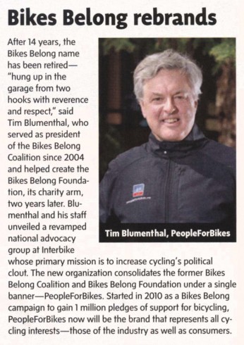
Here’s a little article which appeared in the November 1, 2013 issue of the bicycle trade journal, Bicycle Industry and Retailer News.

Can you say “Astroturf”?

Article from November 1, 2013 Bicycle Retailer and Insudtry News

Article from November 1, 2013 Bicycle Retailer and industry News

I wouldn’t claim to represent the interests of the bicycle industry — but PeopleforBikes, a bicycle industry lobby — claims to represent my interests and those of other individual citizens, er, “consumers”.

For a while last summer it wasn’t possible to go to major bicycle or parts manufacturers’ Web sites without having a PeopleforBikes sign-up-and support popup blot out the start screen. Or as the article puts it,

[s]tarting in 2010 as a Bikes Belong campaign to gain 1 million pledges in support of bicycling, PeopleforBikes will now be the brand that represents all cycling interests — those of the industry as well as consumers.

— not that interests are even the same across the industry. There’s another article in the same issue of Bicycle Industry and Retailer News describing retail bicycle shops’ long-drawn-out problems with one brake manufacturer’s products. I might have concerns too if I bought a bicycle with those brakes, and not to speak of the thrust and scope of industry lobbying which, as you might imagine, is targeted almost entirely at getting government to spend your and my tax dollars on infrastructure projects which PeopleforBikes has decided will get more people to buy bicycles and related products. This has a very decided slant toward separated paths and barrier-separated bikeways on streets, because that is what non-bicyclists and infrequent bicyclists — the great majority of the American population — think they need.

I spend much more than the average person does on bicycle stuff, but I hold to my own opinions about what I buy, and about how to improve bicycling, thank you very much. You may read my opinions on bicycling politics on this blog, and about reliability, safety and good purchasing choices on sheldonbrown.com.

This isn’t the first post on this blog about these issues. It’s just that the one-big-happy-family claim has become more blatant with the rebranding.

Posted in Bicycling | 14 Comments

Bike Box at Charlesgate East

This post is about the intersection of Commonwealth Avenue eastbound and Charlesgate East in Boston, Massachusetts, an intersection with a “bike box” — a waiting area for bicyclists downstream of where motorists stop for traffic signals. More generally, this post is about the assumptions underlying the bike-box treatment, and how well actual behavior reflects those assumptions.

I have described bike boxes more generally on a Web page. There is a discussion of them also in photos assembled by Dan Gutierrez. If you are logged into facebook, you can bring up the first photo and click through the others (“Next” at upper right). Non-members of facebook, the world’s largest private club, can view the slides one by one by clicking on this link.

Dan Gutierrez has also released videos of bike box behavior here and here.

On Wednesday, September 19, 2012, I rode my bicycle to Charlesgate (see Google satellite view for location), with video cameras. I observed traffic for about an hour and shot clips of bicyclists passing through the intersection.

The bike box at this intersection is intended to enable a transition from the right side to the left side of a one-way roadway. (There is a study of a similar treatment in Eugene, Oregon, intended to enable transition from left to right. That study was released in two different versions, one from the U. S. Federal Highway Administration and another from the Transportation Research Board.)

I have now produced a video from my clips. Please view the video in connection with this article. You may view it at higher resolution on the vimeo site by clicking on the title underneath.

Bike Box at Charlesgate East from John Allen on Vimeo.

A Look at the Intersection

Let’s take a virtual tour, examining a longer stretch of Commonwealth Avenue than the video does.

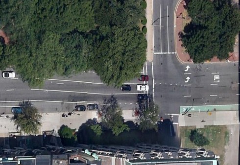
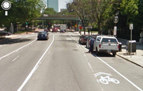
West of Charlesgate West on Commonwealth Avenue, there is a bike lane in the car-door zone, tapering down to nothing before the intersection with Charlesgate West. Bicyclists can still slip by on the right side of most motor vehicles.

At some time following the initial installation, the City painted shared-lane markings near the right side of the rightmost travel lane. I have observed bicyclists riding at speed in the slot between the parked and moving vehicles,  at risk of opening car doors, walk-outs, merges from both sides and right-hook collisions. The purpose of shared-lane markings is to indicate that a lane should be shared head to tail, not side by side. These markings should be placed in the middle of a lane rather than at its edge.

Transition from bike lane to no bike lane to bike lane at right edge. Note, no shared-lane markings yet in this aerial view (Google Maps aerial view)

Transition from bike lane to no bike lane to bike lane at right edge. Note, no shared-lane markings yet in this aerial view (Google Maps aerial view)

Bike lane tapered to nothing in the door zone approaching Charlesgate West

Bike lane tapered to nothing in the door zone approaching Charlesgate West (Google Street View image)

Between Charlesgate West and Charlesgate East, parking is prohibited, and the curb line at the right edge is farther to the right. The rightmost lane used to be a wide, general purpose travel lane —  but nobody who knew the intersection drove a motor vehicle in this lane. A motorist who drove in this lane would be trapped to the right of other through traffic when it became a parking lane after Charlesgate East.

In or around 2010, bike lanes and a so-called “bike box” were installed at Charlesgate East.

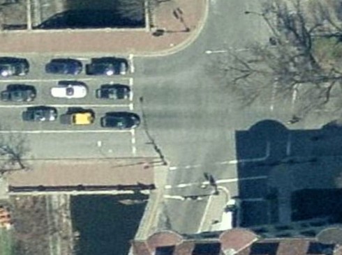
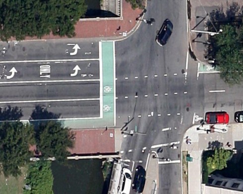
The intersection with Charlesgate East as it existed before 2010 is shown in the first of the two photos below. The intersection with changes is shown in the second photo.

Intersection of Commonwealth Avenue and Charlesgate West before the additional of a bike lane (Microsoft Bing aerial view). Though there is an arrow indicating that the right lane is for through travel, it is unused, because it leads to a row of parked cars in the next block. It is a "musical chairs" lane.

Intersection of Commonwealth Avenue and Charlesgate East before the addition of a bike lane (Microsoft Bing aerial view). Though there is an arrow indicating that the right lane is for through travel, it is empty, because it leads to a row of parked cars in the next block. It is a “musical chairs” lane.

Lane reassignment at Charlesgate East: four usable travel lanes, a musical chairs bike lane, Also note left-side bike lane after the intersection.

Following the changes at Charlesgate East: four usable travel lanes, and a musical chairs bike lane. Also note left-side bike lane after the intersection, top right corner of image. (Google Maps aerial view)

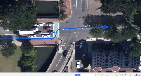
A bike lane is on the left side of the roadway (upper right in the photo above) leads to an underpass. The  transition from the right side to the left side is supposed to be made by way of the “bike box”, with bicyclists swerving left across two lanes of motor traffic to wait facing the left-side bike lane as shown in the image below. Bicyclists headed for other destinations are also supposed to use the “bike box,” waiting in the appropriate lane.

Intended route for bicyclists using the "bike box".

Intended route for bicyclists using the “bike box”.

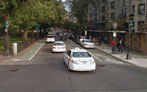
The right-side bike lane is now the “musical chairs” lane which leads into a parking lane. The City has, in a peculiar way, acknowledged this, painting what I call a “desperation arrow” just after the intersection. It is visible at the right in the photo below. It directs bicyclists to swerve  into the right-hand travel lane in the short distance before the first parked car.

Looking across Charlesgate East. The Desperation Aroow is visible at the right side of the roadway. (Google Street View)

Looking across Charlesgate East. The desperation arrow is visible at the right side of the roadway and the bike lane to the underpass is at the left side. (Google Street View)

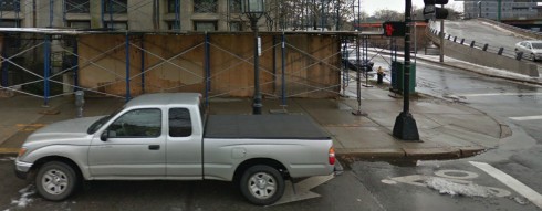
When the closest metered parking spot to the intersection is occupied, the parked vehicle sits directly over the “desperation arrow”.

Vehicle parked legally at metered parking spot, over the desperation arrow.

Vehicle parked legally at metered parking spot, over the desperation arrow.

The designated route is not the only important one. The left-side bike lane after the intersection reduces the width of the other lanes — a particular problem for bicyclists who continue in the rightmost travel lane. Many do, in order to continue at street level rather than using the underpass.

Bicyclist Behavior

I observed that most bicyclists approached Charlesgate East in the green-painted bike lane. It is the prescribed approach to the intersection, even though it is not satisfactory for any destination.

On reaching the intersection, many bicyclists ran the red light, yielding to cross traffic. in this way, they avoided being trapped to the right of moving motor traffic. Cross traffic was easily visible and relatively light, at least in mid-afternoon when I observed it.

The bike box can serve as a waiting area only on the red light. Approaching the intersection as the light turns from red to green or on the green requires bicyclists to merge left; otherwise, they are caught short by the parked cars on the far side of the intersection.

After crossing the intersection, most bicyclists merged into the door zone of the parked vehicles in the next block. If they did this on the green, they were at the same time being overtaken by motorists. Some bicyclists looked over their left shoulder for traffic as they merged; others did not.

I saw a couple of very odd maneuvers: two bicyclists who entered on the red light and crossed from right to left in the middle of the intersection as if that were the location of the bike box — one of these bicyclists continuing in the left side bike lane, the other merging back to the right. I saw one bicyclist who made a sweeping left turn from the bike lane.

I did not see even one bicyclist swerving into the bike box as intended. This observation is consistent with Dill and Monsere’s research in Portland, Oregon. To swerve into the bike box when the traffic signal is red is to gamble on when the light will turn green, crossing close to the front of motor vehicles whose drivers are in all likelihood looking ahead at the traffic signal. A tall vehicle in the near lane can hide a bicyclist from a driver in the next lane. Often, also, motor vehicles encroach into the “bike box”, making it difficult or impossible to enter. Those bicyclists who knew about the underpass —  and chose it — merged across easily if they ran the red light, but got caught waiting at the desperation arrow, if they entered on the green light.

A few bicyclists merged out of the bike lane before reaching the intersection. Some of these, too, ran the red light, and others waited for the green. It should be noted that there are long periods in the traffic signal cycle when the block between Charlesgate East and Charlesgate West is mostly empty, making merging easy.

Improve the Situation?

So, what does this show? For me, the central lesson of all this is that the bike box is supposed to solve a problem which it cannot solve.

Also, because entering the bike box is a gamble, it is a violation of traffic law. Massachusetts General Laws, Chapter 89, section 4, states:

When any way has been divided into lanes, the driver of a vehicle shall so drive that the vehicle shall be entirely within a single lane, and he shall not move from the lane in which he is driving until he has first ascertained if such movement can be made with safety.

I’m especially concerned about bicyclists who lack basic bike handling and traffic skills being dropped into this environment which claims to remove the need for those skills but which in reality requires outsmarting the system. This leads to hazardous behavior and fear.

What could improve the situation here? I see parking as a crucial issue. Removing the 20 or so parking spaces in the block following Charlesgate East would cure the “musical chairs” situation at the intersection — well, mostly.

Vehicles would still stop to load and unload. There is no way that bicyclists can ride safely without knowing how to negotiate merges. Wherever bicyclists may travel, someone may be about to overtake. Removal of parking is a political long shot, to be sure, but on the other hand, the few parking spaces on Massachusetts Avenue can only hold a small percentage of the vehicles of people who live or work in the same block. Isn’t there a possible alternate parking location?

Improved traffic-signal timing might ease merging from the right side to the left side of the roadway in the block before Charlesgate East. Wayfinding signs and markings encouraging merging before reaching the intersection would be helpful.

In my video, I show bicyclists crossing Charlesgate East in a crosswalk. That is not to operate as a driver, but it is practical and reasonably safe because there is no right-turning traffic from Commonwealth Avenue, and traffic on Charlesgate East is not permitted to turn right on a red light. Crossing two legs of an intersection in crosswalks to get to the bike lane on the far side involves waiting through an additional signal phase. Also, a Boston ordinance prohibits riding a bicycle on a sidewalk.

One way of resolving the issue of the traffic signal’s changing as a bicyclist enters the bike box is to enable entry concurrent with a pedestrian signal interval.  Then bicyclists must wait before entering the bike box and again once having crossed it.  Considering the percentage who are unwilling to wait even through one signal interval, there would probably be even more resistance to waiting through two. Another blog post, with a video, examines travel times through two intersections in Phoenix, Arizona with this type of crossing.  The travel times are unreasonably long.

Legalizing bicyclists’ crossing Charlesgate East when motorists are held back would require a separate bicycle signal. A green signal for bicyclists after the green signal for cross traffic would not delay many motorists. There would be significant delay though, for bicyclists, tempting them to run the red light. The earlier they can cross before parallel motor traffic starts, the more time they have to merge before motor traffic behind them starts up. How soon the traffic clears is going to vary greatly with time of day.

I’d like to make a case for a “bicycle boulevard”– a street which bicyclists can use for through travel, but where barriers and diverters require motorists to turn at the end of the block, on Marlborough Street, to the north of Commonwealth Avenue; and/or Newbury Street, to the south. There would have to be a new bridge across the Muddy River at Charlesgate; for Newbury Street, also a tunnel under a ramp to the overpass; or Marlborough Street, a connection under the Bowker Overpass to Beacon Street and Bay State Road. I have suggested elsewhere that Bay State Road be reconfigured as a two-way bicycle boulevard.

Such a bridge might be an element of a redesign of Charlesgate Park — originally an attractive link between Olmsted’s Emerald Necklace park system and the Charles River Esplanade, now blighted by the Bowker Overpass which looms over it. However, the Bowker overpass crosses the Massachusetts Turnpike Extension, a limited-access highway.  Restoring ground-level access maintaining access across the Turnpike would require major reconstruction.


Save

Posted in Bicycling | Tagged , , , , , , , , , , , , , , , , , | 10 Comments

Robo-safety?

An article in the Detroit News describes advances in robo-car technology.

And this raises the question: what kinds of car-bike crashes could this technology prevent?

As suggested in the article: rear-end collisions and drift-out-of-lane collisions. Also perhaps right hooks, if a vehicle has sensors and robo-control to inhibit turning across the path of an overtaking vehicle. In all of these collisions, the bicycle or other vehicle to whom a robo-car might yield is, if not in full view of the driver — so robotics would mitigate driver distraction — in full view from a sensor somewhere on the vehicle.

Dooring collisions and drive-outs from parking? Yes, if a sensor in the side-view mirror prevents the door from opening. But this doesn’t prevent the cyclist from striking a pedestrian who walks out to get into the vehicle, and also prevents a person from getting into or out of the car, also potentially presenting a hazard. The real world is inhabited by real people, not only robotic cars.

Could robotics prevent head-on and ride-out collisions? Only unreliably, because of larger distances and greater closing speeds, and because the cyclist, or a pedestrian, or another car, or a deer leaping across the road — may have been hidden around a curve, or may suddenly appear from concealment. The robo-protection might prevent a vehicle from crossing the center of the roadway, or rounding a curve too fast to yield to traffic ahead — but this only works without drastically lowering travel speed if the vehicle, person or animal to be avoided  is operating properly (e.g. oncoming cyclist is on the correct side of the roadway, pedestrian does not dart out into the street).

Left cross collisions? NOT, if the cyclist is overtaking other vehicles, or parked vehicles, close to the curb, where concealed by them.

All in all, then, the technology could:

* greatly reduce the risk collisions for cyclists and others  traveling according to the  rules of the road;

* Significantly reduce the risk of car-bike collisions for cyclists edge riding or riding in a bike lane to the right of other traffic;

* be of little or no help when cyclists are riding in a bikeway concealed behind a barrier, or crossing in a crosswalk.

The potential for robotic control to prevent collisions is, then, very similar to that of an alert driver — though with additional ability to look in more than one direction at once, and into blindspots. Why? Because the rules for efficient and safe interaction — the rules of movement — aren’t any different when robotics are in control.

And I’ll also draw a more sweeping conclusion: robotic technology, once universally and correctly implemented on motor vehicles, would very significantly improve the safety of cyclists and pedestrians, and make rumble strips, a real problem for cyclists, pointless. Many other facilities-based solutions also would become white elephants.

This is assuming that the technology reflects a real traffic mix on streets, including non-motorized travelers, rather than some fantasy vision of a motorist’s utopia.

I’m only discussing technology here which can be implemented independently on each vehicle, without its communicating with others. There have been utopian schemes described in which all vehicles would communicate and negotiate with one another, avoiding the need for traffic signals, but except on limited-access highways, those pose a very daunting challenge due to the need for instant wireless communication with wide bandwidth, and that not all moving objects can be instrumented, nor would people tolerate this on their bodies — also, that a monkey wrench could be thrown into such systems, bringing traffic to a stop, simply by pedestrians’ walking out into the street. The Atlantic magazine has an article describing such a scheme — as usual in its articles about transportation, short in attention to unintended consequences.

Now, am I guilty of the same, in my optimism?

Posted in Bicycling | 11 Comments

A million bucks to build it, another million to tear it out

Build it wrong, and you may have to spend as much money tearing it out as you did putting it in. This is not a new problem — it is the story of public housing developments of the 1950s, now being torn down; of a number of urban Interstate highways, and of recent road reconstruction as well — see the “money quote” at the end of a post I wrote earlier today, on another blog.

Some people are going to say this won’t happen with today’s cycletracks, but I predict that it will, for three fundamental reasons: most of them are poorly designed; robotic safety equipment in motor vehicles will make the only kind of crashes which they prevent, hit-from-behind crashes,  a non-issue within 30 years; and mode shares will change, in some ways which are predictable, others not, so the paradigm of cars vs. bikes will then be not only unfair, but also obsolete, like a black/white segregated school system in a community which has experienced a wave of Hispanic and East Asian immigrants. The ascendancy of electrically assisted bicycles, already underway, is a step in that particular direction. Motor motor scooters, cargo tricycles, pedicabs…just ain’t gonna fit.

Patricia Kovacs, of Columbus, Ohio, has diligently recovered documents about a cycletrack failure in that city in the 1980s, from the archive of the Lantern, the University of Ohio’s student newspaper,. She explains them as follows:

A cycletrack was built on High Street for 11 blocks along the east side (business side of the street) of Ohio State University. This was a 4′ bike lane at street level, with a 3′ service island on the left of the bike lane. One of the articles of the day called it an 11 block bowling alley.On the west side of the street (campus side), a yellow line was painted in the middle of the sidewalk to separate the pedestrians from the “bike path” (this side at sidewalk level).

The cycletracks were a failure. The 3′ service island did not prevent the cycletrack from being used as a loading zone. The cycletrack collected trash because the university, the city streets department and the city parks department pointed fingers at each other regarding who was responsible for maintenance. Nobody had a sweeper that would fit in the 4′ gutter. This area of campus has/had at least 3 bars on each block, and you can imagine the broken bottles on the weekends, especially during football season. The only good thing about this cycletrack is that it brought the local bike shops a lot of business patching flat tires.

The cycletrack on the west side was a hazard to pedestrians and cyclists. There might have been signage or pavement markings to indicate the “bike path”, but everyone ignored it. How is a pedestrian supposed to yield to a cyclist when crossing the street? This is one of the major issues I see with the new cycletrack designs.I was a graduate student when this cycletrack existed, and I recall riding in it once and then avoided it like the plague.The city spent $1M to build the cycletrack in 1980, and spent another $1M to remove the cycletrack in 1986. I’m surprised it lasted that long.

I have attached several articles from the Lantern, the OSU student newspaper, about these cycletracks. The articles include more details on the problems with the cycletracks for pedestrians, cyclists, motorists and business owners. The article titled “Bike paths cause more harm than good”, has a photo of the gutter cycletrack. The article titled “Renovation nearly finished” shows a cyclist riding the wrong way in the gutter cycletrack (I guess he figured that was safer than negotiating the pedestrians on the other side). The article titled “Street renovation improves safety” cited a 29% decrease in crashes. Well, since they stubbed off 4 out of 11 streets, you would expect crashes to decrease by 36%. And who knows if the crashes included bike/ped crashes?

The articles: September 24, 1980: “Renovation nearly finished”

October 13, 1981: “City cannot clean up bike path”

October 27, 1981: “Street renovation improves safety”

July 9, 1982: “Bike paths cause more harm than good

January 27, 1986: “Bike path victim of bad planning”

November 28, 1986: “Building a New Look”

Posted in Bicycling | 5 Comments

The Poseur

I get buzzed by another cyclist on the Minuteman path.

This is a high-definition video. You get the full experience if click on “YouTube” under the image, expand it to full screen and click on the little gear wheel under the image to get 720 or 1080 resolution.

Posted in Bicycling | 8 Comments

Response to Adam Auster’s comment about Arlington Center

I’m responding to Adam Auster’s comment on my previous post:

On the other hand the route would cross the sidewalk, which can be quite busy, 3 times. (To say nothing of the crosswalk because you already mention it.)

Let’s compare the actual conflicts:

Eastbound traffic, in the town’s plan:

(I also discussed this in my previous message.)

Eastbound cyclists headed from the path mix with sidewalk traffic on the northwest corner of Massachusetts Avenue and Mystic Street. There are 16 different movements on the corner: from each of the five entrances: the path, the two sidewalk directions and the two crosswalk directions to each of the other four. Only two of those movements are unlikely: those between the path and the Mystic Street sidewalk, which both go in nearly the same direction. In addition, this corner is where crowds wait to cross the street. This is a very complicated and confusing situation, where bicyclists, pedestrians and vehicles in the street are concealed by one another.

The eastbound cyclists then cross Massachusetts Avenue on a protected signal phase (though with some risk from illegal right turns from Mystic Street) and are directed to wait in a two-way left-turn area in the middle of the busy intersection until the traffic signal changes. Cyclists are protected by traffic-signal timing as long as they leave the two-way left-turn area promptly, and this is not obvious. The two-way left-turn area is too small to accommodate the likely volume of traffic.

The cyclists are expected to continue from eastwards in the bike lane on the south side of Massachusetts Avenue, which crosses three driveways, and then turn right either at a meandering path before Swan Place, or into Swan Place (It isn’t clear which, from the town’s drawing). From Swan Place, they enter he continuation of the path.

Eastbound bicycle traffic, in my proposal:

Eastbound cyclists turn left to cross across the west-side Mystic Street sidewalk where there are only two conflicting movements: sidewalk traffic in either direction. It isn’t quite clear in the drawing I revised, but I would have cyclists cross on the side of the crosswalk which is away from Massachusetts Avenue.

Eastbound cyclists then cross Mystic Street on the same signal phase as pedestrians. This crossing from west to east is the most troublesome for me, because of the potential for motorists turning right from Mystic Street not to yield to the cyclists. On the other hand, the crossing is signal-protected with a no turn on red sign and/or separate right-turn signal. For this reason and because of the width of the crosswalk and path, a right-turning motorist will be looking for sidewalk and path traffic rather than looking left for Massachusetts Avenue traffic. Most bicyclist left-to-right in crosswalk collisions occur where the motorist is looking left for traffic.

The other likely potential conflict here is with right-turning traffic from Massachusetts Avenue, but here, bicyclists are in full view of the motorists and the bikeway is far enough from the corner that motorists have time to yield.

Eastbound cyclists then cross the sidewalk on the far side of Mystic Street, but again where there are only two movements with which they must negotiate: sidewalk traffic in either direction on Mystic Street.

Bicycle traffic and sidewalk traffic cross over each other in front of Whittemore Park, as shown in the drawing, but again there are only two conflicting movements with which bicyclists must contend. One hardly even counts as a conflicting movement, as the bicyclists are traveling in the same direction as the pedestrians and pass them either on the left or on the right, depending on timing.

Cyclists then cross Massachusetts at the signal-protected crossing to Swan Place. There are no potential conflicts except with bicycle and motor traffic turning left from Swan Place onto Massachusetts Avenue. Cyclists continue on Swan Place, turning left into the continuation of the path. There is a potential conflict with oncoming traffic, as with any left turn on a two-way roadway, but this traffic is very light.

Westbound bicycle traffic, in the town’s plan:

(I also discussed this in my previous post.)

Cyclists turn right from the path onto Swan Place and jog to the right into a bike lane, creating potential confusion for motorists who think the cyclists are turning right onto Massachusetts Avenue. . They then cross at the newly signalized intersection and turn sharply left into a bike lane.
The bike lane is hidden behind vehicles waiting to turn right, until it bears right to be on the right side of the right-turn lane.
Cyclists turning the corner are is in theory protected by a no turn on red signal and separate signal phase, but as noted by several commenters at the public hearing, right turns on red still occur. There is a risk of right-hook collisions and long-vehicle off-tracking crashes.
The bike lane jogs over to the right around the corner, and then cyclists swerve left into a bike lane. Again there is the risk of confusion because the bicyclists appear to be going straight, however, they are on a protected signal phase.
Bicyclists cross in the bike lane or “crossbike” and then must beat their way through the crowd of people waiting on the corner, making one of the 16 possible movements here.

Westbound bicycle traffic, in my proposal:

Cyclists turn right from the path onto Swan Place and continue to Massachusetts Avenue. They then cross at the newly signalized intersection and turn left to continue past Whittemore Park.
The first potential conflict cyclists encounter is with pedestrian traffic on the sidewalk. They are crossing from left to right, so they must yield to oncoming pedestrians and merge either in front of or behind pedestrians traveling in the same direction.
Cyclists then cross the Mystic Street sidewalk, with only two conflicting movements, same as for westbound cyclists.
At Mystic Street, the cyclists cross on a protected signal phase along with pedestrians. There is risk of collision with motorists who turn right, both at the start and end of the crosswalk, but again, these motorists would be turning right on red illegally, and the bikeway is away from the corner, reducing the risks in the same way as described for eastbound cyclists.
Cyclists then cross the Mystic Street sidewalk, where there are two conflicts, and cross the very unlikely conflict with traffic turning sharply left onto the Mystic Street sidewalk from the extension of the path.
Pedestrians are expected to take entirely different routes using the sidewalks. I predict that many cyclists will continue to use the sidewalks.

Posted in Bicycling | 8 Comments

Further suggestions for Arlington Center

On the evening of November 6, 2013, I attended a public hearing about the Arlington Center project. A representative of the city described the town’s plan. There were some changes and clarifications of what was shown at Town Day, and described before the hearing in Adam Auster’s blog post. (Also see his newer posts since the meeting). For one thing, the right-angle parking on Swan Place is gone. As had been pointed out, drivers in two of the parking places would have had to back out into a crosswalk, and  drivers in any parking space would back out across the path of bicyclists.

I left the meeting as the discussion shifted to parking, but the graphic I saw indicated that the new plan is to find replacement parking spaces one by one around the town center. Adam Auster’s blog post goes into more detail about that. One important clarification was that we got at an idea of the traffic signal plan — which would include a special bicycle signal intended to alleviate the conflict between right-turning motor vehicles and through-traveling bicyclists at the northeast corner of Mass. Ave. and Mystic Street.

Still, many attendees commented, as I did, that right-hook collisions were likely here with a bike lane to the right of a right-turn lane, because motorists frequently turn right on the through arrow.  Many raised objections to the zigzag, pillar-to-post proposed routing for bicyclists (shown in green in the drawing below).

My previous post started by describing how a confident adult cyclist could go through the intersection east to west operating as a driver. I embedded a video illustrating that. But I also said that continuity of the path would be important for young and novice cyclists. Let me now illustrate what I consider to be a promising option. I described it briefly in my previous message, and at the meeting.  I’ve added it to the town’s drawing, below. You may click on the drawing to enlarge it.

Possible bicycle route through Arlington Center

Possible bicycle route through Arlington Center

The red line indicates a route for westbound Rail-Trail traffic and the blue line, eastbound Rail Trail traffic. The dark gray lines represents a barrier and curb extension. Is anyone surprised that I would make this suggestion? Get over it! I’m a confident road cyclist but I also ride the Rail Trail, and I’m also a realist. What I propose is going to work better than the Town’s current proposal, and would be preferred over any on-road route by many if not most Rail Trail  users. On the other hand, what I propose, unlike the Town’s proposal, does not complicate bicyclists’ travel on the road!

Advantages as I see them:

  • My proposal continues the path as a path through Arlington Center, consistent with the expectations of Rail-Trail users.
  • It makes full use of the new signals at Swan Place for two-way bicycle travel, rather than only one-way.
  • If timing of the signals is adjusted appropriately, bicyclists crossing Swan Place on a green light would reach Mystic Street just as the signal changes to allow them to cross, and vice versa.  With an average anticipated bicycle speed of 10 mph and motor vehicle speed of 30 mph, this is probably achievable.
  • My proposal avoids the need for the two-way left-turn waiting area in the middle of an intersection (at the right-angle between the two green bike lane segments at left in the drawing.)
  • It avoids messing with Massachusetts Avenue, and in particular, it avoids the attempt to have a westbound bike lane on Massachusetts Avenue serve conflicting purposes as a through route and route to the Rail Trail.
  • It avoids the need for any special traffic signal phases or timing, or added delay for street traffic beyond that imposed by the traffic signal at Swan Place, which is already in the plans.
  • It avoids the driveway crossings on the south side of Massachusetts Avenue. No driveways cross my proposed route.
  • It takes advantage of the unusually wide sidewalk in this area. Is there a possibility of moving the fence back and making the sidewalk even wider — or placing the path  in Whittemore Park, like the one which is already proposed for Uncle Sam Park?
  • Bicyclists using this route eastbound could turn left and continue on Mass. Ave.
  • This route has bicycle and pedestrian traffic cross each other away from intersections, rather than in the crowds on the corners of an intersection, avoiding confusion and sight obstructions.

Potential problems and concerns:

  • This proposal uses sidewalk space and/or parkland. Arlington is concerned with bicyclists’ using sidewalks — but, primarily, the south sidewalk on Massachusetts Avenue, requiring crossing two legs of the major intersection with Mystic Street/Pleasant Street. Let me suggest that the Town’s current proposed design will do little to reduce sidewalk use, and particularly, westbound. What would reduce sidewalk use is to have a more attractive off-street route — and to remove the path leading to the Massachusetts Avenue south sidewalk from Swan Place.
  • Bicyclists would ride in the crosswalk area across Mystic Street in both directions.  Crossing from right to left in a crosswalk, in particular, has been shown to be hazardous. On the other hand, this is already an established crosswalk, and to be blunt about it, I don’t see any alternative other than a grade separation which would realistically result in less use of crosswalks.
  • Strong signage and markings would be needed to direct eastbound Rail-Trail users to turn left into the crosswalk area  at Mystic Street to continue on the Rail Trail. I suggest a special bicycle signal to indicate clearly that the crossing at Mystic Street is for the Rail Trail.
  • Three or four parking spaces on the north side of Massachusetts Avenue would need to be removed to continue the trail to the signalized intersection at Swan Place. (Whether the six parking spaces and taxi stand on the south side would also still be removed, is a different question. That certainly would free up space for through travel and a median. The Town does appear to have found several replacement parking spaces. Can it find a few more?)

Additional Comments:

What I have shown is only a sketch. If anything like it is to become reality, technical and political issues would have to be resolved.

The town held up the intersection of New Hampshire Avenue, U Street and 16th Street NW in Washington, DC as an example of a treatment using a special bicycle signal. Problem is, I know that intersection well. I have studied it extensively and it does not work. You may read about it here. Bicyclists at that  intersection do not use the two-way left-turn area: they instead ride in the crosswalks, taking the most opportunistic route depending on the signal phase. That is what also happens in Arlington Center, and will continue to happen with the town’s proposed design.

Posted in Bicycling | 7 Comments

Arlington Center westbound — avoiding the right hook

The Town of Arlington, Massachusetts has proposed changes to the intersection of Massachusetts Avenue with Mystic Street/Pleasant Street (really one street, which changes name at the intersection).

I’ve posted a video of a bicycle ride I took through Arlington Center, here:

This video has now been extended with a clip of a second ride through the intersection in May, 2017, when the changes to the intersection were mostly complete.

The ride is easy, and especially because the left turn for Swan Place can only be made when traffic isn’t approaching from the east on Massachusetts Avenue anyway. So, I simply turned into the through lane and kept going. If the leftmost through lane is the only one open, as in my video, it’s an easy merge into the next lane, because the traffic will only be just starting up at the traffic light, at the same time a bicyclist has to merge.

Why Do They shoot Themselves in the Foot?

Graphic from CommuteOrlando site

Graphic from CommuteOrlando site

So, why do other bicyclists in the video shoot themselves in the foot, threading their way along in the narrow space at the right side of the right turn lane — slow, and complicated — and potentially far worse, risking getting themselves right-hooked on the corner?

Just as a refresher about the right hook, CommuteOrlando in Florida has the page, What Bicyclists Need to know About Trucks, including the graphic at the right.

The advice is clear and simple: don’t overtake into the danger zone next to a truck (or a car, or a bus…). The two drawings below convey the same message. You may have seen them already.

Truck blind spots Right hook riskJust in case you might discount the Orlando advice as Not From Here, the drawings below are copied from pages 100 and 101 of the Massachusetts Driver’s Manual (pages 22 and 23 in the PDF of Chapter 4).

All the people in control of the bicycles in my video are grown-ups. All of them will have had many years of experience in traffic, in motor vehicles. Almost certainly, most of them hold driver’s licenses. So, why should they be intentionally and blatantly doing exactly what the Driver’s Manual warns against? These bicyclists are violating the most fundamental principles of traffic safety, just because they happen to be riding bicycles.

To make a complicated explanation simple, it’s because they have been taught to be afraid of traffic coming from behind them, and to ignore other risks — even where those are serious and the risk of traffic from behind is very small. I’m reminded of a saying by the late, great Dutch traffic engineer Hans Monderman:

Never treat anyone in the public sphere like an idiot. If you treat him like an idiot, he will act like an idiot.

But, that’s another discussion. Let’s move on. To ride as I did and avoid the right hook:

  • Check for traffic, and turn right from the path onto Swan Place.
  • Turn left from the middle of the right lane on Swan place into the closest open lane on Mass. Ave.
  • If necessary, merge right into the rightmost through lane. This is easy because traffic will be waiting at the traffic light ahead, and just starting up as you need to merge.
  • Continue across Mystic Street and either keep going straight on Mass. Ave., or turn right at the far side of the intersection to go to the path.


About the Proposed Design

Now, moving on to discuss the proposed design: why should street design encourage exactly the behavior for bicyclists which is disparaged for motorists as deadly dangerous? Bicyclists are after all more vulnerable — so, we should also render bicyclists defenseless?

This design is what was installed as of May, 2017, with four significant differences, all of which I would count as improvements: There are no new parking places with a twisty path behind them on Swan Place, the  green bicycle route extending from Swan Place starts nearer the middle of the right lane, it has a larger curve radius as it turns left onto Massachusetts Avenue, and the route from right to left across Mystic Street extends directly from the bike lane on Massachusetts Avenue rather than from the street corner.

Right hook collisions have become the single largest cause of bicyclist fatalities in the Boston area as designs which encourage passing on the right have become more prevalent.

Why does the proposed design have to formalize this suicidal behavior — and also, encourage motorists to turn right illegally from the lane to the left of the bike lane? Why can’t the design encourage other, more efficient and safer behaviors? Not only the one shown in my video, either. There are good off-road alternatives too. Please read on.

To understand the problems, it helps to look at the plan view, below. You can click on it to enlarge it.

Arlington Center, Massachusetts

Arlington Center, Massachusetts

The assumptions behind this drawing are clear enough: bicyclists are witless wonders, capable of only following a green, painted path — but on the other hand, capable of following it where it abruptly shifts right and left and goes around sharp corners. Motorists are 100% cooperative and attentive, and also have the superhuman ability to see bicyclists outside the range of their rear-view mirrors. We can forget everything we know about safety at intersections: painting the pavement green solves all problems. We can ignore the traffic law which requires right turns to be made from the right edge of the roadway.

Specifics: Westbound

Now, as to specifics, we start again at Swan Place, at the lower right. Here is what the proposed design would have bicyclists do.

  • Bicyclists turn right onto Swan Place. Motorists backing out of the new, proposed parking spaces on the west side of Swan Place will back out into the path of the bicyclists.
  • There is a shared-lane marking before the intersection. Good enough — bicyclists need to ride in the middle of the narrow lane, that’s the appropriate lane position to prepare a left turn, and that’s easy enough on this lightly-traveled street, BUT then the bike lane  to cross Massachusetts Avenue is at the right side of the intersection! Bicyclists are being instructed to bear right, as if they are going to turn right onto Mass. Ave., and then abruptly swerve left. A bicyclist following this designated route needs to be looking back to the left for motorists approaching on Mass. Ave. and back to the right for motorists turning right from Swan Place. The bicyclist’s having first turned right makes it look to motorists as if he or she intends to turn right onto Mass. Ave., risking motorist mistakes and crashes. Bicyclists should instead simply continue across Mass Ave. in line with the shared lane marking. Then they only have to look left and right for traffic. With the traffic light proposed for the intersection, the way will probably be clear on a green light, though it’s best to look anyway. Or is that too simple, and too safe?
  • Bicyclists are next instructed to continue straight across all the lanes of Mass. Ave, to the bike lane on the other side, and swerve sharply left to where the bike lane continues in the door zone of parked cars. The driver of a parked car checking whether the door would strike a bicyclist must look back at the right moment to see that a bicyclist has turned left and is headed for the door. This is worse because the corner in the bike lane is too sharp for bicyclists to negotiate, and they will cut the corner.
  • Here, the bike lane also is directly behind vehicles waiting in the right turn lane.  This requires motorists preparing to turn right to look in their right-hand rear view mirrors at just the right time, or else miss seeing the bicyclist.
  • Where a right turn lane follows the parking spaces, the bike lane is striped to its right, leading bicyclists into a “coffin corner” where they can collide with motor vehicles, and can be swept under the rear wheels of turning trucks and buses.
  • On the corner,  the bike lane is interrupted. It resumes several feet to the right, around the corner. To reach it, the bicyclist again turns right to go straight. But here, there are separate signal phases for right-turning traffic, through traffic and the crosswalk. Which traffic signal is the bicyclist supposed to obey? A bicyclist turning right on the right-turn signal will immediately be in conflict with right-turning motor traffic if swerving left to cross Mystic Avenue. There is no space to wait before swerving left, so bicyclists will pile up on the corner when bicycle traffic is heavy — or more likely, will ignore the bike lane across Mystic Street and continue straight across, still risking the right hook. Is a bicyclist at the right side of the right turn lane permitted to go straight across on the pedestrian signal? on the through phase? Are motorists allowed to turn right on the through  phase? Who knows?
  • On reaching the far side of Mystic Street, a bicyclist has to take care, passing through the crowd of pedestrians waiting, and walking in multiple directions, but may then turn right and head for the path. On the other hand, a bicyclist continuing on Mass. Ave. has to go around another corner. It is very much simpler, faster and safer, as my video shows, to continue straight through on the road.

Now, granted, some — many — of the bicyclists using the Minuteman are children and novices, who would be more comfortable crossing Mystic Street in the crosswalk. BUT the design doesn’t offer any convenient way to get from the street to the crosswalk, even though the sidewalk becomes much wider as it approaches Mystic Street. There is also no ramp down to the bike lane across Mystic Street — there is only a narrow ramp down to the far side of the crosswalk. At the far side of Mystic Street, there is also only a ramp from the crosswalk, none from the bike lane.

Also: how are bicyclists supposed to turn left from Mass. Ave. onto Pleasant Street? They may legally use the left turn lane, driving their bicycles — but if they follow the bike lanes, they will have all of the problems described above and also have to wait for the traffic signal to change once more.

Specifics: Eastbound

I have some problems with the other direction of travel as well.

  • Bicyclists are expected to make the left turn in two steps, meaning that they will have to wait in a small two-way left-turn area. This is too small to hold more than two or three bicyclists at once. The extra wait produces delay.
  • Parking spaces have been removed from Mass. Ave, which is good — no door zone on this side.
  • After the driveway to the parking lot before Swan Place, there is a path to Swan Place, but the plan gives no indication how bicyclists are supposed to reach the path from Mass. Ave.
  • Bicyclists who turn right from Mass. Ave. to Swan Place (or who turn left from Mass. Ave. westbound) ride directly into the path of cars backing out of the right-angle parking spaces on Swan Place.


Some Alternatives


What would I like to see instead?

  • Bicyclists directed straight across from the shared-lane marking on Swan Place, perhaps with dashed lines leading into the intersection.
  • Timing the new traffic signal at Swan Place to clear the westbound lanes of Mass. Ave. before bicyclists get the green light to turn left from Swan Place.
  • Shared-lane markings in the westbound through lanes leading to the intersection with Mystic Street.
  • Eliminate the three parking spaces which create the door-zone bike lane, so there can be a safe bike lane leading to the wide sidewalk on the north side of Mass. Ave.
  • A ramp leading to the wide sidewalk, with a designated part of the sidewalk’s width for bicyclists. This should cross over to the side of the sidewalk away from the street, so bicyclists aren’t crossing through a crowd of waiting pedestrians on the corner.
  • A wide ramp leading down to the crosswalk/bike lane on Mystic Street.
  • That bike lane should be on the side of the crosswalk away from Mass. Ave., so bicyclists again don’t have to pass through the crowd of pedestrians waiting on the corner.
  • A ramp up from that bike lane on the west side of Mystic Street.
  • A signal-protected diagonal crossing so bicyclists headed eastbound can cross the intersection in one step.
  • Forget about the wandering path from Mass. Ave. to Swan Place, so bicyclists just turn into Swan place to get back to the Minuteman headed east.
  • Or as much as I dislike most so-called “cycle tracks”, I’d even go for a two-way path starting at Swan Place opposite the bikeway portal and continuing to Mystic Street on the south side of Mass. Ave., but only if there were no driveways across it, and in connection with a signal-protected diagonal crossing at Mystic Street.
  • Or instead a two-way path in that wide sidewalk area  on the north side of Mass. Ave. all the way from Swan Place to Mystic Street. This would require two street crossings but would not require an additional signal phase at Mystic Street.
  • Find somewhere else nearby to put the few parking spaces that have been eliminated. There’s got to be a better way somehow. Looking at the satellite view, there’s lot of parking in the area and many spaces are empty.

In the long-run, what is really needed here to maintain the quality of the Minuteman is a grade separation for the path. Yes, that’s expensive. But also in the long run, it would pay off in reduced delay and danger for path users, and for everyone traveling through the intersection.

Also see Adam Auster’s post about this project, which covers political issues, and the project’s history.

And I’ve written elsewhere about right hook fatalities and how to avoid becoming one.

Posted in Bicycling | 7 Comments