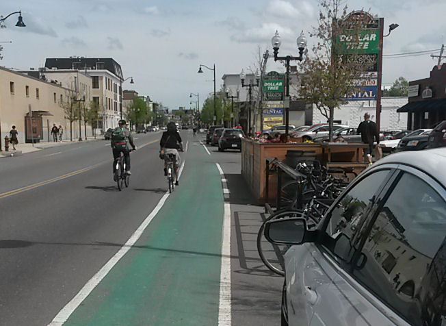
Near the right side of the photo below is a “parklet,” a seating area which replaces a couple of parking spaces on Somerville Avenue in Somerville, Massachusetts, USA. A parklet may also contain a planting, as this one does.
A parklet can be installed only on a street which is wider than it needs to be for travel – typically, where curbside parking is an established reality. In the early part of the 20th century, parking might have been only sporadic for deliveries and pickups of goods, and for buses and taxis to pick up and discharge passengers. Over time, private motor vehicles became more affordable and popular. They increasingly came to occupy the sides of streets, and for longer time periods. Merchants demanded curbside parking; residents also may use it and may value it as traffic calming.
So, a lane on one or both sides of the street has gone out of use for travel, to be used for car storage. The parklet looks like a clever way to reduce parking and avoid increasing travel space for motor vehicles – a double win.
The claim is commonly made for parklets that the street space is being taken back for the use of the people – but which people? People also use the parking spaces, an issue also brought up in another post on this blog. The issue can come down to a locals-vs.-outsiders conflict. That can go either way. Residents object to the loss of parking spaces. Or on the other hand, residents may be unhappy with a deluge of parked vehicles coming in from elsewhere, and there may be a shortage of public space in the neighborhood. Most support I’ve seen for parklets in the Boston area comes from anti-car activists, notably the Livable Streets Alliance. A restaurateur may be willing to trade off the loss of parking spaces for the additional seating, especially if most customers are local.
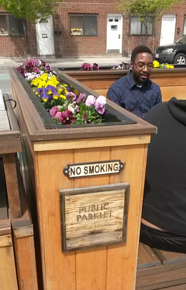
The latter is the case with the Somerville parklet. A restaurateur actually paid for it – and so, it amounts to a repurposing of public street space for private use. though certainly, the same may be said about car storage. One private use of public space gets traded off for another, which is seen as more friendly to the neighborhood. The sign attached to the parklet, shown in the photo above, reads “Somerville’s first Public Parklet, brought to you by the Forge Baking Company.” The Forge Baking company is in the mini-mall upon which the parklet fronts.
Let’s also consider the consequences if a lane on one side of the street has to be closed off to repair underground sewer or water lines. Without a parklet, and if there is parking on the other side, temporary “no parking” signs can be posted and traffic moves over by one lane. Traffic can continue to use as many lanes as before, at the cost of a few parking spaces. The flexibility to convert non-travel space on the street into travel space is very helpful in maintaining the functionality of the street for travel.
When a parklet is installed, the parking spaces can no longer be repurposed as travel space, at least, not without tearing out the parklet. And let’s hope against hope that the parklet doesn’t have to be torn out to replace underground pipes.
A parking space ahead of the Somerville parklet has been repurposed as bicycle parking. This may work to the restaurateur’s advantage, at least in good weather. The bicycle parking would be easier to take out temporarily if required for a construction or street-maintenance project. All in all, there are better places — more secure, sheltered — to park bicycles than in street parking places. But this placement also constitutes a symbolic victory, taking space away from cars for bicycles.
In the case of the Somerville parklet, I’ll actively question how much thought was given to safe traffic operation. Somerville Avenue has typical Boston-area bike lanes, in the door zone of parked vehicles. The parklet here extends nearly to the edge of the bike lane before a parking space, then a driveway, and the wall is high enough to block cyclists’ view of pedestrians and vehicles entering from the right. The two cyclists in the photo at the top of this article know enough to avoid edge-riding risks but not all do.
Anti-car activists relish their symbolic victories but often don’t care to address hard questions of safety, mobility and maintenance. The Somerville parklet is, in my opinion, a case in point.