Up: Table of Contents
Previous: Preface
Next: Alderside Summers
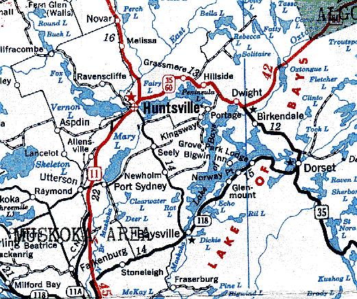
I. DWIGHTDwight is a post office in the township of Franklin, Muskoka District, Ontario. It is situated at the most northern point of the Lake of Bays, and is thirteen miles east and slightly south of Huntsville, the nearest town and railroad station. Huntsville is one hundred and forty-six miles by rail north of Toronto. The surface of the Lake of Bays is 1,034 feet above sea level; its area is 17,000 acres; its shoreline about 105 miles. The average depth of the lake is about 85 feet, and its maximum depth is 235 feet. This latter is at a point about midway between Clovelly and Norway Point. (1) I do not know how the shoreline was measured, or estimated, but presume that fairly straight lines were taken along the sides of bays and inlets as well as in general. Possibly the line following the shore in and out around rocks and points and inlets carefully, is a great deal more than 105 miles. Within a rod or so of the 'big' point on Dwight Bay, I have measured a depth of 156 feet. Dwight actually is a post-office and nothing more, but the name Dwight has come to be applied to the area round about from which most folk come to make use of the post-office. The question as to who was the first white man to see the Lake of Bays must remain unanswered. There have been hints that Norse explorers may have reached the lake hundreds of years ago. We know that Indians travelled the lake long before any modern white man came upon it. The name, Trading Lake, attached to the Dorset end of the lake, reminds us that Rama and Missisauga Indians used to meet there to trade. But for modern settlement and travel, and for the great recent development of summer visitor and tourist trade, it was the explorations of Alexander Murray, Assistant Provincial Geologist, that pioneered the way. The Forester of Huntsville, in its issue of November 7, 1957, published an account of Murray's travels through Muskoka which it had received in a letter from Mr. Norman Massey of London, Ontario, who twenty years earlier had delved into the Provincial Library and come on Murray's report of his trip (2). In his capacity as Assistant Provincial Geologist, Alexander Murray left Lake Huron on June 8, 1853, and in fifty-seven days he and his party, travelling by lake and river, reached Ottawa. He studied the geology of the country, determined the elevations of the lakes, and made a good map. His is the first recorded exploration through the Huntsville area. He was nine days going from Lake Huron to the site of Bracebridge. He chose to ascend the north branch of the Muskoka River, noting the south branch as he passed. The night of the twenty-third of June he camped near the present site of the Locks and the next day he went along the west shore of Fairy Lake to the present site of Huntsville. Then he turned and went by the route familiar to tourists for many years now, through Fairy Lake, the stream (the Canal) and Peninsula Lake, over the portage, around the Lake of Bays, noting how it emptied into the south branch of the Muskoka River, and that the Hollow River emptied into the lake at the east end. He found, however, that the Oxtongue was the largest river flowing into the lake so he followed it up through Oxtongue Lake, and so on to the Ottawa River. He gave the names to Mary's Lake (in his journal 'Mary's', not 'Mary') Fairy Lake and Peninsula Lake - so called "from the peculiarity of its shape". At this point his journal reads:
Oxtongue lake was named from its shape, and Canoe Lake from the fact that the party was delayed there several days to construct a new canoe, the trip up from the Lake of Bays having nearly destroyed the old one. Settlement of Muskoka, and especially of the northern part where Dwight is situated, came slowly. Naturally it came mostly from the south, along the line from Toronto to Barrie, then around by Orillia, Severn, Gravenhurst, and Bracebridge. Toronto, whose name is of Indian origin, meaning "a place of meeting", first appears in history in 1749 "as a center of trade when the French built a small fort and started a trading establishment called Fort Rouille" (Enc. Brit.) Around 1793 Governor Simcoe transferred the seat of government of the new province of Upper Canada to this site, and named it York, which name it retained until 1834, when under the charter of incorporation as a city it was named Toronto. Long before this the Indians travelling from Lake Huron to Lake Ontario avoided the long trip down and through Lake Erie by cutting through Georgian Bay, up the Severn River, through Lakes Couchiching and Simcoe, up the Holland River to what is now Holland Landing. From here they portaged over the 'Toronto Crossing Place' and came out near the mouth of the Humber to Lake Ontario. Lady Eaton told me that this portage passed close to her magnificent country home at King. Governor Simcoe knew about this 'Crossing Place', but felt he needed a shorter military road from York to Holland Landing. Consequently he planned in 1793 to build a straight road up to the Landing. This road, known ever since as Yonge Street, was completed in 1796, and the lake beyond its end was named Simcoe in honor of the governor's father. After York's very slow start (its population in 1818 had grown only to 456) settlement began to move gradually up Yonge Street. Eventually a steamboat was put on Lake Simcoe, and this helped expand the area of settlement up the lake and around Couchiching. Then in the 1850's railroads began to be built into and out of Toronto, and one line, touching at Belle Ewart and Barrie, placed Muskoka within reasonable travelling distance, for passengers could go either to Belle Ewart or to Barrie, and take boat for Severn, and stage from Severn to Gravenhurst, and, after 1866, A. P. Cockburn's steamboat, "Wenonah" from Gravenhurst to Bracebridge. It was not until July 1, 1888, that the District of Muskoka became finally fully detached from the Simcoe district. But as early as 1859 the Free Grant System was put into operation in the district, whereby a settler could get two hundred acres of land free, and an added hundred for every son over eighteen years of age. But settlement was slow. The grants were made at Severn at the most southern point of the district. By 1864 only 163 persons had located, but by 1870 one hundred and thirty-nine thousand acres had been taken up. By 1880 there were 5,100 houses in the district and 27,204 persons. Then in 1886 the Pacific Branch of the Northern and Northwestern Railroad was completed through the heart of the district to Lake Nippissing, where it connected with the Canadian Pacific Railway, and settlement became easy. In the early days of the Free Grant System, some of the settlers had to walk forty miles to Orillia to mail a letter or to buy provisions (3). Muskoka was not slow in setting up newspapers. By 1871 E. F. Stephenson was publishing The Huntsville Liberal, and when it went out of business in 1877, The Huntsville Forester made its appearance in November of that year, and has been published ever since. The following advertisement, copied from the Gazettes of Ontario for the year 1869, is interesting in connection with the modes of travel used by settlers in the early days: N O R T H E R N R A I L W A Y O F C A N A D A From Toronto to Collingwood, 94� Miles BRANCH, BELLE EWART! Gauge of Road 5 feet 6 inches Connections.
|
Lines of approach via Bracebridge and
Baysville,
via Huntsville and via Minden and Dorset.
| Settlers came to Dwight by three routes. Some made their way in
from Minden through Dorset and then by lake to Dwight. Most likely they came by canoe all
the way, portaging from lake to lake, before the time when there was a road from the south
to Dorset. Edmund J. Gouldie, the first setter, storekeeper, postmaster, and for many
years the leading citizen, came this way, arriving in the year 1875. He was a trapper, so
it was not surprising to be told by one of his daughters that he paddled the family in
from Dorset - the family, at that time. consisting of Mrs. Gouldie and two or three of the
dozen with which he was eventually blessed (4). He built his house at
the north-east corner of the bay from which he could look with uninterrupted view all the
way down past Poverty Island. Ed.'s brother, Archie, came a couple of years after him,
according to his daughter Esther (Mrs. Frank Keown). He had the first blacksmith shop, and
he also acted as local undertaker. Much later he built the old Gouldie House. His wife was
midwife for the early settlers, and for years she delivered almost every baby in the
community. Later on William Woodcock brought his family from Minden, and there may have
been others who came the same way. The second route of settlement was north through Baysville. This was natural as Bracebridge was a sort of distributing point for settlers coming to take advantage of the free grants of land, and Baysville is the nearest point on the Lake to Bracebridge. Captain Hawkins operated a crazy steamer on the lake, and it was through Bracebridge and then by this boat that the second family of settlers, the Blackwells, arrived, coming a year after Ed. Gouldie, from Hamilton. William Blackwell had been a stone-cutter in Hamilton, but he was drawn north by the free land grants. He and his family took the land north of the present Highway (No. 60 - 35) along the road to Coopers Lake, and then easterly along the old Concession all the way to Devils Angle Lake, where Ralph Blackwell, a grandson of the old man, has his saw-mill at present. Tom Salmon, then a young, unmarried man, came through Bracebridge and settled with a friend not far away. When the friend left to return to England, Tom followed a surveyor's blazed trail one day and came out at Huckleberry Point on the lake. He was so attracted that he returned in the spring and lived for a while with some Indians. Then he got a boat and went all around the lake and found a place to locate. Eventually, when he married, he settled at Fox Point. This was about 1882. His stay with the Indians was in the spring of 1870. Huntsville has always seemed to us the natural approach to Dwight. The trip, however, from Bracebridge to Huntsville was arduous and longer than that from Bracebridge to Baysville. And then in the early days before the canal was dredged, persons going from Fairy Lake to Peninsula Lake had to pole their way through the little connecting stream, and this continued to be the case for years after the first settlement of Dwight. Captain George Hunt was a settler in 1869, and soon the general location was known as Huntsville. Dr. Francis L. Howland came to the community in 1875 as a needed and young physician, and for years he was its leading citizen. It is unfortunate that the story of his work as a physician has not been preserved in detail, for his trips, night and day, behind his pony team to all sorts of out of the way places, would make a thrilling narrative in medical annals. In 1870 Rev. R. N. Hill came through Huntsville and pressed on to the spot that ever since has borne his name - Hillside. Then with the building of boats and their operation both on the Lake of Bays and on Fairy and Peninsula Lakes by Captains G. F. Marsh and Denton (5), and the extension of the railroad to Huntsville in the year 1886, the shores of all these lakes became easily accessible and the tough days of settlement were over (6). Settlers pressed in past Hillside to Cain's Corners, and fanned out to the north-east towards the Quinn settlement at the head of Long Lake, and south towards the Portage. Among them was James Timothy Haysom, a native of Southampton, England, who with his family settled in 1884 about half a mile east of Cain's Corners in the direction of Dwight. His daughter, Nellie, was married to Sam Wells, May 22, 1888, by my grandfather in the Baptist Church at Dwight, that being the first wedding in the church. Among those who came to settle near Dwight there were some families who had known Grandfather in Durham. From them word went back that they had no preaching, so Grandfather determined to go and minister to them (7). He made his way to Huntsville although there was no railroad that far then, and turned up in Dr. Howland's office to ask his way to Dwight. Dr. Howland introduced him to a young woman who was going to Dwight, and together they made the journey on foot. This was the first coming of a Stewart to the spot now so much a part of the life of the entire family. Grandfather's arrival was probably in 1883, a year before the Haysoms came, and four years before the Baptist Church was built and dedicated as a result of his labors. There was another man, a Mr. Lambert - a colporteur, I believe - who preached and did some Sunday School work near Dwight in these years (8), but it was Grandfather who organized the church, having baptized twenty-six people one day in the lake in front of the site of the church. To enable him to carry on his work as a missionary, Grandfather bought from Ed. Gouldie an acre of land with a log house on it for forty dollars. This log building was part of what remained of a lumber camp on the lakefront west of the Boyne Creek, and it became the nucleus of the later Alderside. A sawmill stood close to the creek between the road and the lake, being part of the camp. This was Kemp's mill, he being, I believe, a relative of William Ketch. Father participated in the dedication of the church on August 17, 1887, and the next summer he took his family from Rochester to Dwight to spend the vacation in grandfathers log house. Ever since, this has been the summer home of the Stewart family. When we arrived at Dwight, only thirteen years after the first settler, we found many settlers who had arrived before us. There were, of course, the Gouldies, and then the Wilders and Ketches who had come from near Durham, and the Thompsons, Woods, Joseph Smiths, Wellses, Haysoms, James CunnInghams, Cains, Goreauxes, Merediths, Keowns, Schafers, old Mr. Pratt, Corporal Davy Griffith, and others. Over on Ten Mile Bay were the Robsons, and at Fox Point, the Salmons. The Osbornes were at the Portage that bears their name. Before our time at Dwight Ed. Gouldie's first house burned down. Old Mr. Schafer, who lived on the hill back of Alderside, remarked to Mrs. Gouldie later - much to her disgust - "I sit on my hill and I see your house burn." It seems that Kemp, who owned the mill, had intended to do custom work for the settlers as they cleared their land. There was not sufficient work of this kind, so he closed his mill, after cutting all the pine on his own place, and took the machinery and moved on. When Ed.'s house burned, the men of the community, including the Blackwell boys, Frank and Dick, got together and took the lumber from the old mill and helped Ed. build a new house. This house was located where the present Logging Chain Lodge stands. When Kemp left, his land came into Ed. Gouldie's hands, and it was in this way that Grandfather's purchase was from him. Besides the log house that Grandfather bought we can remember the remains of the mill, a blacksmith shop, a stable and at least one other building that had belonged to the lumber camp. Kemp had not even cut the trees he felled into lumber, and these were the very ones Alexander Murray had so mach admired on his journey of exploration. For many years an interesting feature our vacations was clearing up the land. These magnificent logs left by Kemp were dragged together and burned, and the stumps were burned out, or dug out and dragged away down to the bank by the lake shore, where remains of some of them may still be seen. It was through Dick and Frank Blackwell that Dwight happened to get its name (9). H. P. Dwight was sent to Toronto about 1850 to take charge of the telegraph lines in that area. At first he was occupied with getting the lines into Toronto, but being a very active man he wanted to push lines out from Toronto in all directions, and in these developments he was sometimes more eager, I believe, than even his company wished him to be. He was interested also in fishing and hunting, and year by year as the country opened up, his trips took him further and further north. Finally he came up through the Muskoka River to the Lake of Bays. By this time he had a number of fiends who accompanied him on these fishing and hunting expeditions, and they had in mind going further up the Muskoka River toward or beyond Oxtongue Lake and establishing a permanent hunting camp. On the Lake of Bays they had five guides for their party, Tom Salmon, Ed. Gouldie, Archie Gouldie, Dick and Frank Blackwell. The Blackwell boys persuaded them to look at Long Lake at the back of their property before deciding where they would locate a camp. This they did, and the result was that they established the Dwight-Wyman Hunting Camp on the shore of Long Lake, six miles from Dwight, sometime in the eighties. For years, each autumn the members of the group gathered at the camp for hunting deer. They had the same five guides for years, and because of Mr. Dwight's position and importance Ed. Gouldie's post office was given the name Dwight. Mr. Wyman's name was given to Captain Denton's steamer, the Erastus Wyman. When the first cabin at the Camp was rebuilt, old Mr. Blackwell constructed the enormous stone chimney and fireplace in it. He earlier built the stone chimney in Alderside. Mr. Dwight was sufficiently important as a businessman that he needed to be able to keep in touch with Toronto when he was away hunting deer. As a consequence he had the telegraph line extended to Dwight, and Ralph Gouldie learned the code and took messages at Dwight - that is, whenever he happened to be around. To picture Dwight in the period of settlement it is necessary, for one thing, to eliminate from the present scene all that modern invention and modern methods of road-building have produced. Today we can travel in a comfortable auto from our city dwelling to our cottage, all the way on paved highway or surfaced roads. The settlers had to ride horseback, walk, or go by water. The easiest method was to go by boat, whenever it was possible. For instance, Ed. Gouldie paddled from Dwight to Baysville to get flour. It is possible, as Frank Blackwell suggests, that he followed a trap-line on this trip, and so made the one journey serve two purposes. However that may be, it was easier to go by water seventeen miles to Baysville than to go by land thirteen miles to Huntsville. Before the post-office was established at Dwight, settlers went to Grassmere for their mail, and as there was no road to begin with, they either walked or rode horseback along a path. Frank Blackwell told me how glad he and others would be to break the long hike back by stopping in at Cain's Corners to get some refreshment. The Bosfields lived at the corners then, and I imagine that Mrs. Bosfield was a good cook and made something the boys specially liked. Gradually roads were built, but only gradually. When we arrived in 1888, there was no road to Oxtongue Lake. Settlers there walked to Dwight for mail. There was no road to Fox Point, none from Marsh's Falls to Birkendale, and none beyond to Dorset. There was no road out the peninsula to Port Cunnington, and I well remember that one day when we were on a steamboat trip a yoke of oxen was taken in to Port Cunnington. The steamer stopped a distance out from the shore, the gangway was opened, and the oxen were pushed off the boat into the water. After what seemed a long time they came to the surface from their plunge, and men from the shore in rowboats guided them in to land. There were many docks around the lake and the steamboats were most obliging in stopping anywhere to take on or leave off passengers or to bring in or take freight. Oxen were often used, being better for the rough country for many purposes than horses. In these days the water was the best highway, and most people had either a canoe or a flat-bottomed punt. The punts were home-made. We had two or three punts, of which I am sure that Mr. Ketch built at least one, before we possessed a skiff. The skiff came in 1895, and was one of the first around the bay. It was a gift from Mrs. Ezra R. Andrews, who was one of our guests that summer. In those days, therefore, there was much more travel on the lake by small boats. On Sunday mornings rowboats and canoes, coming to church, would appear from Wilder's Landing, from the river mouth, from beyond the big point. All this gave rise to a wise remark by Alfred Ketch to the effect that 'You'd think that lake would get wored out with so many skifts goin' on it.' People came long distances for the mail and groceries in small boats. And the steamboats were back and forth on their trips constantly. The boat left Dorset at six in the morning, and it would often be after midnight before it would finish its day's journeying to the Portage and to all the points of call in between and back again. Now motor-boats have driven punts, skiffs and canoes largely off the lake. Highways have meant cars, and cars rave doomed the steamboat service, and much that in the earlier days was picturesque and even beautiful has disappeared from the scene not to return. Mail is delivered at Dwight and at many new offices every day: the daily papers are on sale at the up-to-date stores. Radio and television are as available in what was the back woods as they are in the heart of the city. Something of the sense of great adventure that charmed us on our trips to Dwight when we were children will never be the possession of our children or of our grandchildren. The early settlers who came to the area were of various types. Some were essentially hunters and trappers, and were drawn by the abundance of wildlife. Some were attracted by the offer of free land. Among these were men who had never got on very well and hoped for a new start. The free land provided much: trees from which they could build log houses at almost no cost, logs from which they could get supplies of lumber, new ground in which potatoes grew wonderfully, woods in which there was an abundance of game for fresh meat, access to the lake where there were fish to be had. And, with lumber companies beginning to operate in the region, enough wood-cutting in winter to supply a little cash. With all this, if one kept a cow, and a few hogs, and, maybe, some sheep, he had a fair subsistence living. But when the lumber companies moved their work further along and were not easily accessible for jobs in winter, when the ground lost some of its quality for raising potatoes, and the game began to disappear from the woods, these early farms were deserted and the forests came again in second growth burying the log houses that had once been occupied. I am told that the population of Muskoka in this period dropped from sixty thousand to twenty thousand, and I could name a dozen or more deserted farms in the Dwight area. There were other settlers of fine quality who came: some were English migrating families, and some were city men attracted by the free land. Of these many were disappointed in their land, and after struggling for some years they gave up. Others were able, either because they had picked fair farming land, or because they altered their occupations to fit in with the changing economic possibilities introduced by the flood of summer visitors, to hang on and to do very well. These are now the backbone of the population, a population which is increasing with the development of Muskoka as a tourist and summer resort land. The settlement affected very much the appearance of the countryside. For one thing, a settler's first idea was to clear ground enough for his house and fields. Consequently, every here and there were clearings, often full of stumps, around which wild raspberries grew in profusion. Parts that were cut merely as wood-lots to provide fuel were left uncultivated, or were used as pasture for cattle. Sometimes clearing was done by burning, and a chance wind might carry the fire beyond control of the settler. The great pinery around the river mouth and back for several miles was burned not once, but several times, the last time, I believe, by a fire John F. Wilson had started to clear a new field.(A) The result of all this was that there were on the landscape many bare patches, and some areas of standing dead pine trees whose blackened sides were visible all the way across the bay. Settlers came to look on trees almost as enemies which had to be disposed of if one was to live or make a living. Once I pointed to Schafer's Hill and remarked on its beauty to William Ketch. "Yes", he said, "she'd be beautiful if all them trees were cleared off!" To begin with, roads were primitive and very rough. Rocks and pine roots made them bumpy as could be. We had a hay-ride to Oxtongue Lake once, and mother put tea cups into the basket for our noon meal. As I remember it every cup had lost its handle in the rough drive over the comparatively new road to Oxtongue. At one point the wagon was hauled over a pine tree trunk that had fallen across the road.) Now the highways make travel easy, and bulldozers make possible the rapid construction of side roads wherever they are needed. Such is Dwight. Our family came for vacation to Alderside only thirteen years after Ed. Gouldie came as the first settler, and we have watched the gradual changes ever since. The landscape, due to the rapid second growth of trees, is much more beautiful than it was when we came. The dead pines have fallen, and in their place are the magnificent new pines, fifty to eighty feet high. And due to the dam at Baysville, the lake is always kept at high level, and like the 'river of God' described by the Psalmist, is 'full of water.' (1). Facts supplied by the Lake of Bays Association booklet for 1957. These are modest measurements compared to those which were current belief among the early settlers, and which we commonly held to as accurate - lacking any careful confirmation. To us, the lake was 1400 feet above sea level; it had 365 miles of shoreline, and it was 1400 feet deep. In fact, there was believed to be an immeasurably deep hole somewhere in it. (2)When may brother Fred was studying history at Harvard he had access to the stacks in the library, and there he found, preserved in the private library of Prescott, the American historian, Murray's report made to the Upper Canada government. In it he read all that appeared in The Huntsville Forester, and in addition, the statement that Murray, coming around from Portage Bay into Dwight Bay saw the finest stand of pine anywhere on his travels along the north shore of the bay, just where our cottages are now. Fred adds, "I suppose we helped dig out and burn the stumps of some of these trees." The only sign of white man that Murray reported was some blaze marks on trees close to the falls at Bracebridge. (3)The material regarding the settlement of the District of Muskoka was found in "A Peek Behind the Scenes", a booklet published by the Orillia Packet and Times in 1935 as a souvenir for the annual meeting of the Canadian Weekly Newspaper Association, held that year in Toronto. (4) This information is taken from an article in the Telegram, Toronto, Saturday November 8, 1958, entitled "A Heart of Gold". The reporter talked with Mrs. Frank Keown, Frank Blackwell - who was ninety-four in 1958 - and Mrs. Jessie Irwin. (5)"the inauguration of a regular local boat service, first by Captain Denton followed by the late Captain Marsh --- late in the 1880's - etc." Our First Twenty Years - The Rotary Club of Huntsville. (6)"Huntsville was virtually without settlement, until William Cann, a hunter and fisherman from Orillia, built a small cabin just west of the location of the present Main Street bridge." A few other fishing cabins were built in the same area. "Captain George Hunt, of Montreal, located east of the river, and built the first log cabin residence in that locality. ----Captain Hunt, who became the first Postmaster, was honored with the choice of a name for the new community. The office was named Huntsville and this name was given to the village municipality when it was organized in 1886." Our First Twenty Years. (7)See article by Alex, The Huntsville Forester, Thursday, October 23, 1947. (8)Mrs. Sam Wells told me this, also that the mill was Kemp's. Frank Blackwell said it was Kemp's. The names Robinson and Fetterly are also associated with the mill. (9) Frank Blackwell told me about the naming of Dwight. |
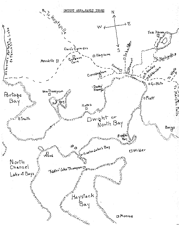
Map of Dwight area, early years
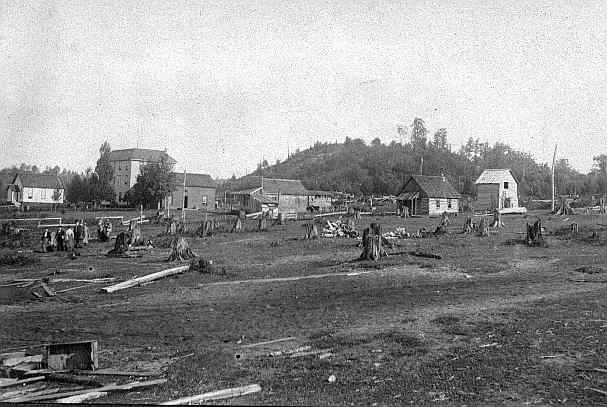
| Dwight, 1903, looking towards the old Gouldie Manor.
Note in this snapshot the log schoolhouse pictured in James Arnold's drawing on another
page. Paul Hahn, 7 Linwood Avenue, Toronto, a friend of Douglas Atkinson's, sent me this picture. On the reverse side it says, "Taken August 11, 1903 by Emanuel Hahn, on a canoe trip up the Oxtongue River to Ragged Lake, Algonquin Park. Dr. Edward Walker (son of Sir Edward) Paul Hahn and Emanuel Hahn. Arthur Gouldie, Guide." |
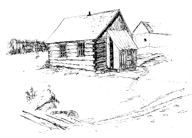
| Pioneer School house at Dwight, Lake of Bays, Ont. Canada. Drawing by James Burns Arnold of Rochester, N. Y., 1895 [Caption by Alexander M. Stewart] |
Up: Table of Contents
Previous: Preface
Next: Alderside Summers
%20rotated.jpg)